IMAGES TAKEN NEAR TO
Stratfield Saye, READING, RG7 2DH
Introduction
This page details the photographs taken nearby to RG7 2DH by members of the Geograph project.
The Geograph project started in 2005 with the aim of publishing, organising and preserving representative images for every square kilometre of Great Britain, Ireland and the Isle of Man.

There are currently over 7.5m images from over14,400 individuals and you can help contribute to the project by visiting https://www.geograph.org.uk
Image Map
Images are licensed for reuse under creativecommons.org/licenses/by-sa/2.0
Notes
- Clicking on the map will re-center to the selected point.
- The higher the marker number, the further away the image location is from the centre of the postcode.
Image Listing (15 Images Found)
Images are licensed for reuse under creativecommons.org/licenses/by-sa/2.0
Image
Details
Distance
1
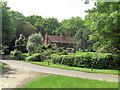
Laylands Cottage
This Grade II listed cottage dates from the 17th C and has English Heritage Building ID: 139105.
Image: © Stuart Logan
Taken: 31 May 2013
0.00 miles
2

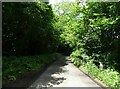
House on Mill Lane
For a picture from 2013 and more information see http://www.geograph.org.uk/photo/3487677.
Image: © Shazz
Taken: 1 Nov 2014
0.00 miles
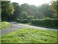
4

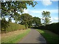
Junction of Mill Lane and Great Dover Street
Mill Lane bends to the right.
Image: © Shazz
Taken: 1 Nov 2014
0.03 miles
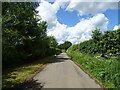
8
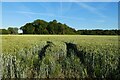
Farmland, Stratfield Saye
Wheat and a copse to the south-east of Fair Oak Green.
Image: © Andrew Smith
Taken: 20 Jun 2022
0.06 miles