IMAGES TAKEN NEAR TO
Mayflower Meadow, READING, RG7 1YD
Introduction
This page details the photographs taken nearby to Mayflower Meadow, RG7 1YD by members of the Geograph project.
The Geograph project started in 2005 with the aim of publishing, organising and preserving representative images for every square kilometre of Great Britain, Ireland and the Isle of Man.

There are currently over 7.5m images from over14,400 individuals and you can help contribute to the project by visiting https://www.geograph.org.uk
Image Map
Images are licensed for reuse under creativecommons.org/licenses/by-sa/2.0
Notes
- Clicking on the map will re-center to the selected point.
- The higher the marker number, the further away the image location is from the centre of the postcode.
Image Listing (8 Images Found)
Images are licensed for reuse under creativecommons.org/licenses/by-sa/2.0
Image
Details
Distance
1
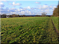
Pasture, Three Mile Cross
A footpath follows the edge of the field before a slight descent to the village.
Image: © Andrew Smith
Taken: 12 Dec 2009
0.08 miles
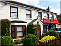
2
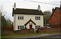
Rendered 'Lawrence Dene' on east side of Basingstoke Road
Image: © Luke Shaw
Taken: 6 Nov 2019
0.09 miles
3
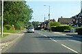
B3349 Basingstoke Road
Towards Reading.
Image: © Robin Webster
Taken: 18 Jul 2021
0.10 miles
4
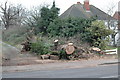
Oak tree fallen in high wind
At northern most end of Spencers Wood on west side of road. Tree fell 18/01/07.
Image: © nicholas99
Taken: 19 Jan 2007
0.21 miles
5
Versatile building
Formerly "The Cricketers" coaching inn this building is now partially used as an off licence and media rental service called "Hop Inn".
Image: © Shazz
Taken: 9 Aug 2014
0.21 miles
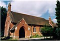
7
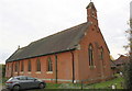
St Michael's Church, Basingstoke Road
There is an OS benchmark Image on the near corner, right hand face, of the church
Image: © Luke Shaw
Taken: 6 Nov 2019
0.22 miles
8
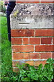
Benchmark on St Michael's Church, Basingstoke Road
Image: © Luke Shaw
Taken: 6 Nov 2019
0.22 miles