IMAGES TAKEN NEAR TO
Lambwood Hill, READING, RG7 1JQ
Introduction
This page details the photographs taken nearby to Lambwood Hill, RG7 1JQ by members of the Geograph project.
The Geograph project started in 2005 with the aim of publishing, organising and preserving representative images for every square kilometre of Great Britain, Ireland and the Isle of Man.

There are currently over 7.5m images from over14,400 individuals and you can help contribute to the project by visiting https://www.geograph.org.uk
Image Map
Images are licensed for reuse under creativecommons.org/licenses/by-sa/2.0
Notes
- Clicking on the map will re-center to the selected point.
- The higher the marker number, the further away the image location is from the centre of the postcode.
Image Listing (17 Images Found)
Images are licensed for reuse under creativecommons.org/licenses/by-sa/2.0
Image
Details
Distance
1
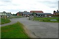
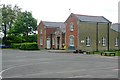
Diddenham Court
Some of the buildings of Diddenham Manor Farm have been converted into small office and business units.
Image: © Graham Horn
Taken: 19 May 2009
0.03 miles
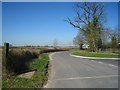
2
Access to Didenham Court
Converted farm buildings for small businesses on the outskirts of Reading.
Image: © Fernweh
Taken: 27 Mar 2012
0.04 miles
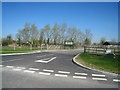
5
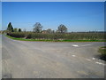
Lane junction south of Grazeley Manor
Wood Lane.
Image: © Fernweh
Taken: 27 Mar 2012
0.15 miles
6
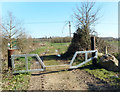
Bridleway Gate, Grazeley
This is a good, fit for purpose sort of gate. Solid enough to keep vehicles out but easy for horses to step over.
Image: © Des Blenkinsopp
Taken: 15 Mar 2017
0.17 miles
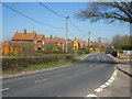
7
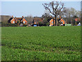
Farmland and houses, Grazeley
Houses on the main road viewed over a cereal crop from the footpath to the west of the church.
Image: © Andrew Smith
Taken: 17 Apr 2010
0.17 miles
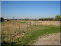
9
Grazeley School
The parochial primary school, taken from Mereoak Lane. The history of Grazeley website here http://www.grazeleyvillagehall.org.uk/?p=grazeley-village tells us that "it was built in 1861 at a cost of £441 16s 9d", with extensions in 1893 and 1913 to accommodate more pupils. The playground is in Image but the school building is in this square, which is probably the more appropriate one.
Image: © Graham Horn
Taken: 19 May 2009
0.20 miles
10
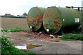
Thurley Farm
Fuel storage tanks at the edge of one of the arable fields.
Image: © Graham Horn
Taken: 19 May 2009
0.21 miles