IMAGES TAKEN NEAR TO
Winston Close, READING, RG7 1DW
Introduction
This page details the photographs taken nearby to Winston Close, RG7 1DW by members of the Geograph project.
The Geograph project started in 2005 with the aim of publishing, organising and preserving representative images for every square kilometre of Great Britain, Ireland and the Isle of Man.

There are currently over 7.5m images from over14,400 individuals and you can help contribute to the project by visiting https://www.geograph.org.uk
Image Map
Images are licensed for reuse under creativecommons.org/licenses/by-sa/2.0
Notes
- Clicking on the map will re-center to the selected point.
- The higher the marker number, the further away the image location is from the centre of the postcode.
Image Listing (9 Images Found)
Images are licensed for reuse under creativecommons.org/licenses/by-sa/2.0
Image
Details
Distance
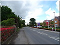
2
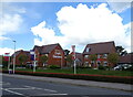
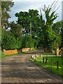
Croft Gardens
New housing development, Spencers Wood.
Image: © JThomas
Taken: 24 May 2022
0.07 miles
3
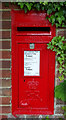
Elizabeth II postbox on Hyde End Road (B3349), Spencers Wood
Postbox No. RG7 92.
Image: © JThomas
Taken: 24 May 2022
0.12 miles
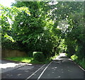
5
Sussex Lane, Spencers Wood
A byway giving access to a few residences. It continues as a footpath towards Swallowfield.
Image: © Andrew Smith
Taken: 4 Jun 2008
0.18 miles
6
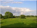
Pasture, Spencers Wood
Fields at the end of Sussex Lane immediately south of the Hyde End area of Spencers Wood.
Image: © Andrew Smith
Taken: 4 Jun 2008
0.19 miles
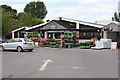
7
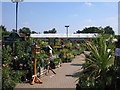
Grovelands Garden Centre
off Hyde End Road (B3349), south of Reading between Shinfield and Spencers Wood.
Image: © C D Uglow
Taken: 17 Aug 2005
0.22 miles
9
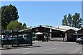
Dobbies Garden Centre from Hyde End Road
Image: © Roger Templeman
Taken: 14 Jul 2014
0.24 miles