IMAGES TAKEN NEAR TO
Woodcock Court, READING, RG7 1BZ
Introduction
This page details the photographs taken nearby to Woodcock Court, RG7 1BZ by members of the Geograph project.
The Geograph project started in 2005 with the aim of publishing, organising and preserving representative images for every square kilometre of Great Britain, Ireland and the Isle of Man.

There are currently over 7.5m images from over14,400 individuals and you can help contribute to the project by visiting https://www.geograph.org.uk
Image Map
Images are licensed for reuse under creativecommons.org/licenses/by-sa/2.0
Notes
- Clicking on the map will re-center to the selected point.
- The higher the marker number, the further away the image location is from the centre of the postcode.
Image Listing (17 Images Found)
Images are licensed for reuse under creativecommons.org/licenses/by-sa/2.0
Image
Details
Distance
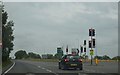
1
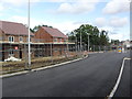
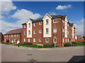
Grazeley Road
Houses under construction in Three Mile Cross.
Image: © Burgess Von Thunen
Taken: 3 Oct 2012
0.08 miles
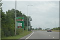
2
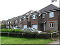
Grazeley Road
2000s houses in Three Mile Cross.
Image: © Burgess Von Thunen
Taken: 3 Oct 2012
0.11 miles
3
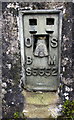
Benchmark on the Highbury trig point pillar
Ordnance Survey flush bracket (identifier S5552) benchmark on the pillar Image
Image: © Roger Templeman
Taken: 6 Nov 2019
0.12 miles
4
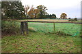
Paddocks near Highbury triangulation pillar
There is an OS benchmark set into the left hand face of the pillar Image: more information of the pillar is at http://trigpointing.uk/trig/3818
Image: © Roger Templeman
Taken: 6 Nov 2019
0.14 miles
7
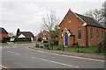
Three Mile Cross
The Wesleyan Chapel, dated 1876, in the village of Three Mile Cross south of Reading.
Image: © Brendan and Ruth McCartney
Taken: 16 Apr 2005
0.17 miles
9
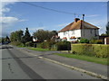
Grazeley Road
1930s council houses in Three Mile Cross.
Image: © Burgess Von Thunen
Taken: 3 Oct 2012
0.17 miles
10
Fawn Drive, Three Mile Cross
This whole block to the north west of the crossroads has been built up with new housing. There is a bit of a theme going on as regards street names here. This is Fawn Drive, and nearby are Sika Gardens, Elk Path and Caribou Walk.
Although for some reason the main road through the estate is called Tabby Drive.
Image: © Des Blenkinsopp
Taken: 22 Apr 2015
0.19 miles