
IMAGES TAKEN NEAR TO
Chilcombe Way, READING, RG6 3DB
Introduction
This page details the photographs taken nearby to Chilcombe Way, RG6 3DB by members of the Geograph project.
The Geograph project started in 2005 with the aim of publishing, organising and preserving representative images for every square kilometre of Great Britain, Ireland and the Isle of Man.

There are currently over 7.5m images from over14,400 individuals and you can help contribute to the project by visiting https://www.geograph.org.uk
Image Map
Images are licensed for reuse under creativecommons.org/licenses/by-sa/2.0
Notes
- Clicking on the map will re-center to the selected point.
- The higher the marker number, the further away the image location is from the centre of the postcode.
Image Listing (5 Images Found)
Images are licensed for reuse under creativecommons.org/licenses/by-sa/2.0
Image
Details
Distance
1
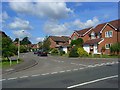
Swepstone Close, Lower Earley
Looking into the cul-de-sac from its junction with Kilnsea Drive.
Image: © Andrew Smith
Taken: 13 Jun 2008
0.19 miles
2
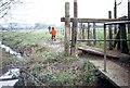
Mill Lane Reading Earley
Stile and footpath leading from Mill Lane to fields bordering the River Loddon before the development of Lower Earley.
Image: © norman griffin
Taken: 28 Dec 1972
0.20 miles
3

Junction of Silverdale Road and Gipsy Lane
Image: © Roger Templeman
Taken: 24 Jul 2014
0.20 miles
4

Gipsy Lane, 1982
Until the expansion of the Lower Earley housing development, this was on the edge of the countryside.
Image: © Alan Murray-Rust
Taken: 24 Nov 1982
0.22 miles
5
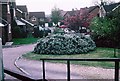
Lower Earley
Towards the east, and the older part of the huge Lower Earley expansion, the houses are smaller, still in leafy, sinuous culs-de-sac. Shops and services are scarce and residents are dependent on the car. This is still an area of very high house prices though.
Image: © Rosalind Mitchell
Taken: 28 Apr 2005
0.22 miles