IMAGES TAKEN NEAR TO
Highdown Hill Road, READING, RG4 8QP
Introduction
This page details the photographs taken nearby to Highdown Hill Road, RG4 8QP by members of the Geograph project.
The Geograph project started in 2005 with the aim of publishing, organising and preserving representative images for every square kilometre of Great Britain, Ireland and the Isle of Man.

There are currently over 7.5m images from over14,400 individuals and you can help contribute to the project by visiting https://www.geograph.org.uk
Image Map
Images are licensed for reuse under creativecommons.org/licenses/by-sa/2.0
Notes
- Clicking on the map will re-center to the selected point.
- The higher the marker number, the further away the image location is from the centre of the postcode.
Image Listing (8 Images Found)
Images are licensed for reuse under creativecommons.org/licenses/by-sa/2.0
Image
Details
Distance
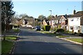
1
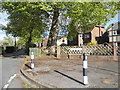
Cherwell Road at the junction of Gravel Hill
Image: © David Howard
Taken: 3 May 2015
0.12 miles
3
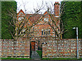
Old Grove House
A 17th century house, the front part of which is constructed in brick and flint - for architectural details, see http://www.imagesofengland.org.uk/Details/Default.aspx?id=39206 .
The side of the building is shown here Image .
Image: © Rose and Trev Clough
Taken: 5 Mar 2014
0.14 miles
4
Old Grove House, Emmer Green
An old manor house now surrounded by modern suburb.
Image: © Des Blenkinsopp
Taken: 27 Mar 2012
0.15 miles
5
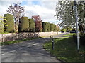
Tredegar Road, Emmer Green, Reading
The road dips down into Hemdean Bottom and leads to more roads with Welsh names.
Image: © Andrew Smith
Taken: 6 Nov 2020
0.17 miles
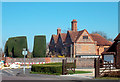
6
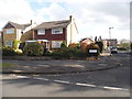
Tredegar Road at the junction of Penn Close
Image: © David Howard
Taken: 3 May 2015
0.18 miles
7
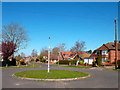
Eric Avenue
The roundabout at the end of Eric Avenue, with an old style street lamp on it.
The Reading street map calls this Watership Down although that isn't on any other map.
Any idea who Eric was?
Update, 15/11/12 :- Many thanks to Nick Wright for mailing the following, which solves the Eric mystery and sheds some light on the Watership Down puzzle.
"I saw your image and comment on Eric Avenue. According to an elderly neighbour (unfortunately now deceased) who had lived in Eric Avenue since the houses were built, Eric was the name of the builder. And Watership Down is almost certainly the name of one of the houses on the roundabout before you get to Gorselands. There are lots of fake rabbits in their front garden!"
That's wonderful, and thinking about it, who better to name a street after than the man who built it? We should have more Fred Streets and Wladyslaw Crescents.
Image: © Des Blenkinsopp
Taken: 27 Mar 2012
0.19 miles
8
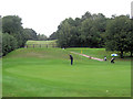
He could hit this ball right out of the county
The golfer taking the putt is standing on the 5th green in Oxfordshire but behind the photographer lies Berkshire. The 5th hole is a beautiful downhill par 4 of 325 yards. It's the easiest on the course. Behind the fence and up the steep sides of Highdown Bottom is the par 3, 6th hole. Just 136 yards but a challenging shot to the green, which is well protected by bunkers S.I. 16.
Image: © Stuart Logan
Taken: 17 Sep 2013
0.24 miles