IMAGES TAKEN NEAR TO
Keats Way, CROWTHORNE, RG45 6QS
Introduction
This page details the photographs taken nearby to Keats Way, RG45 6QS by members of the Geograph project.
The Geograph project started in 2005 with the aim of publishing, organising and preserving representative images for every square kilometre of Great Britain, Ireland and the Isle of Man.

There are currently over 7.5m images from over14,400 individuals and you can help contribute to the project by visiting https://www.geograph.org.uk
Image Map
Images are licensed for reuse under creativecommons.org/licenses/by-sa/2.0
Notes
- Clicking on the map will re-center to the selected point.
- The higher the marker number, the further away the image location is from the centre of the postcode.
Image Listing (9 Images Found)
Images are licensed for reuse under creativecommons.org/licenses/by-sa/2.0
Image
Details
Distance
1
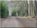
Oaklands Lane, Wokingham Without
A residential byway to the north of Crowthorne.
Image: © Andrew Smith
Taken: 11 Feb 2006
0.05 miles
3
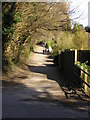
Oaklands Lane, Crowthorne
Unmade road that leads to Hatch Ride and Oaklands School
Image: © don cload
Taken: 2 Mar 2009
0.13 miles
6
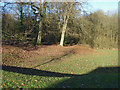
Water cachment area, The Brackens
A small open area on the junction of The Brackens and New Wokingham Road which acts as a water cachement area with a drain that flows under New Wokingham Road into Heath Lake.
Image: © Alan Hunt
Taken: 10 Dec 2014
0.18 miles
7
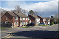
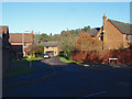
Lupin Ride, Crowthorne
A new estate to the north of Crowthorne.
Image: © Andrew Smith
Taken: 11 Feb 2006
0.19 miles
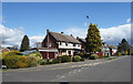
8
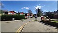
Hinton Drive
Dead end road leading to Hatch Ride Primary School.
Image: © James Emmans
Taken: 2 Apr 2021
0.20 miles
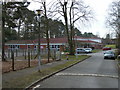
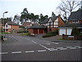
9
Otter Close, Crowthorne
One of the short closes off Merryman Drive in the new housing estates to the west of Crowthorne.
Image: © Alan Hunt
Taken: 10 Dec 2014
0.24 miles