IMAGES TAKEN NEAR TO
Clater Grove, BRACKNELL, RG42 6DW
Introduction
This page details the photographs taken nearby to Clater Grove, RG42 6DW by members of the Geograph project.
The Geograph project started in 2005 with the aim of publishing, organising and preserving representative images for every square kilometre of Great Britain, Ireland and the Isle of Man.

There are currently over 7.5m images from over14,400 individuals and you can help contribute to the project by visiting https://www.geograph.org.uk
Image Map
Images are licensed for reuse under creativecommons.org/licenses/by-sa/2.0
Notes
- Clicking on the map will re-center to the selected point.
- The higher the marker number, the further away the image location is from the centre of the postcode.
Image Listing (50 Images Found)
Images are licensed for reuse under creativecommons.org/licenses/by-sa/2.0
Image
Details
Distance
1
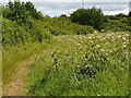
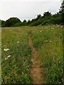
Overgrown footpath at Larks Hill
A footpath overgrown with grass and weeds at Larks Hill.
Image: © Oscar Taylor
Taken: 5 Jun 2020
0.08 miles
2
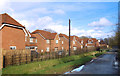
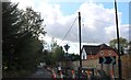
Watersplash Lane, Newell Green
An old lane now part of a building site as Bracknell takes over.
Image: © Des Blenkinsopp
Taken: 28 Jan 2020
0.08 miles
3
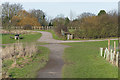
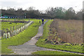
Larks Hill Country Park, Bracknell
The country park off Harvest Ride north of Bracknell.
Image: © Alan Hunt
Taken: 16 Feb 2016
0.08 miles
4
Path to Watersplash Lane
A path leading out of Larks Hill to Watersplash Lane, through a gate.
Image: © Oscar Taylor
Taken: 14 Jun 2020
0.08 miles
5
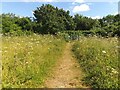
Overgrown footpath at Larks Hill
A footpath at Larks Hill bordered by dense weeds and grass.
Image: © Oscar Taylor
Taken: 10 Jun 2020
0.09 miles
7
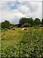
Cows at Larks Hill
Cows grazing on the long grass at Larks Hill.
Image: © Oscar Taylor
Taken: 5 Jun 2020
0.10 miles
8
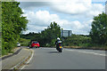
A3095 Newell Green
Leaving Bracknell northwards towards Maidenhead.
Image: © Robin Webster
Taken: 9 Jun 2019
0.11 miles
9
Larks Hill Country Park, Bracknell
The country park north of Harvest Ride at the northern edge of Bracknell.
Image: © Alan Hunt
Taken: 16 Feb 2016
0.12 miles
10
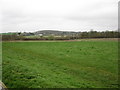
Wick's Hill open space
The hill is largely a grassed open area but there is a community orchard on the northern edge of the field.
Image: © don cload
Taken: 29 Mar 2010
0.12 miles