IMAGES TAKEN NEAR TO
Horatio Avenue, BRACKNELL, RG42 3TJ
Introduction
This page details the photographs taken nearby to Horatio Avenue, RG42 3TJ by members of the Geograph project.
The Geograph project started in 2005 with the aim of publishing, organising and preserving representative images for every square kilometre of Great Britain, Ireland and the Isle of Man.

There are currently over 7.5m images from over14,400 individuals and you can help contribute to the project by visiting https://www.geograph.org.uk
Image Map
Images are licensed for reuse under creativecommons.org/licenses/by-sa/2.0
Notes
- Clicking on the map will re-center to the selected point.
- The higher the marker number, the further away the image location is from the centre of the postcode.
Image Listing (5 Images Found)
Images are licensed for reuse under creativecommons.org/licenses/by-sa/2.0
Image
Details
Distance
1
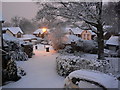
Snowy Warfield
Early morning snow in Warfield, Bracknell.
Image: © Alan Burke
Taken: 8 Feb 2007
0.07 miles
2
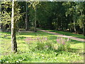
Purple Loosestrife at Lily Hill Park
The hollow where these flowers grow must be damper than the rest of the park. Lily Hill Park is maintained by Bracknell Forest Borough Council, with wildlife in mind, and is very pleasant to walk in.
Image: © Liz
Taken: 19 Aug 2005
0.18 miles
3
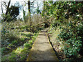
Boardwalk over the swampy bit
Just off Harvest Ride there is a small area of damp woodland, a remnant of what was here before the whole place was built over. There is a footpath through the middle of it.
Image: © Des Blenkinsopp
Taken: 13 Mar 2017
0.20 miles
4
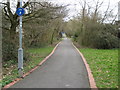
Bullbrook: Footpath and cycle track from Jig's Lane South
There are several of these broad 20 metre wide avenues that run between the modern housing estates of Bullbrook, east of Bracknell. Ahead is the Hamlet Street crossing. This avenue and its surrounding residential area are in the grounds of the former Warfield Park estate. A look at the 1881 Edition of the Ordnance Survey map shows that Bracknell and Bullbrook were then two similar sized but quite separate villages. Bullbrook has now been subsumed into the town of Bracknell.
Image: © Nigel Cox
Taken: 12 Mar 2009
0.23 miles
5
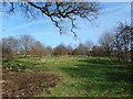
A bit of a park
A patch of informal open space amongst all the houses. I guess it's called something, but there wasn't a name by the way I came in and there isn't one on the map.
Image: © Des Blenkinsopp
Taken: 13 Mar 2017
0.24 miles