IMAGES TAKEN NEAR TO
Darby Vale, BRACKNELL, RG42 2PL
Introduction
This page details the photographs taken nearby to Darby Vale, RG42 2PL by members of the Geograph project.
The Geograph project started in 2005 with the aim of publishing, organising and preserving representative images for every square kilometre of Great Britain, Ireland and the Isle of Man.

There are currently over 7.5m images from over14,400 individuals and you can help contribute to the project by visiting https://www.geograph.org.uk
Image Map
Images are licensed for reuse under creativecommons.org/licenses/by-sa/2.0
Notes
- Clicking on the map will re-center to the selected point.
- The higher the marker number, the further away the image location is from the centre of the postcode.
Image Listing (29 Images Found)
Images are licensed for reuse under creativecommons.org/licenses/by-sa/2.0
Image
Details
Distance
1
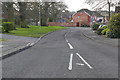
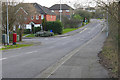
Darby Vale, Bracknell
Looking west along Darby Vale in the housing estates in north Bracknell.
Image: © Alan Hunt
Taken: 16 Feb 2016
0.03 miles
3
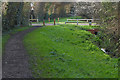
Path beside drain, Bracknell
A walkway off the Quelm Path following the course of a drain running into The Cut near Harvest Ride. The road is an extension to Marbull Way.
Image: © Alan Hunt
Taken: 16 Feb 2016
0.05 miles
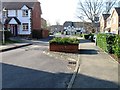
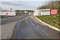
4
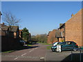
Mareshall Avenue, Bracknell
The roundabout at the junction of Mareshall Avenue and Darby Vale in the northern suburbs of Bracknell.
Image: © Alan Hunt
Taken: 16 Feb 2016
0.07 miles
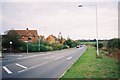
5
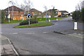
Newport Drive, Bracknell
Newport Drive running south from the Harvest Ride roundabout into the housing estates to the north of Bracknell.
Image: © Alan Hunt
Taken: 16 Feb 2016
0.07 miles
7
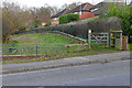
Footpath off Newport Drive, Bracknell
A footpath following the line of a drain off Newport Drive in the northern suburbs of Bracknell.
Image: © Alan Hunt
Taken: 16 Feb 2016
0.08 miles
8
Town meets country, Bracknell
At the junction of Harvest Ride and Totale Rise, with Long Copse in the distance.
Image: © Andrew Smith
Taken: 8 Nov 2005
0.09 miles
9
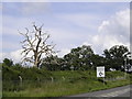
Dead Tree near Quelm Park Roundabout
Image: © Julian P Guffogg
Taken: 7 Jun 2008
0.11 miles
10
Northern relief road, Bracknell
The entrance to the roadworks off the Harvest Ride roundabout. The road connects with the Maidenhead Road near its junction with Forest Road.
Image: © Alan Hunt
Taken: 16 Feb 2016
0.12 miles