IMAGES TAKEN NEAR TO
Windmill Road, BRACKNELL, RG42 1TT
Introduction
This page details the photographs taken nearby to Windmill Road, RG42 1TT by members of the Geograph project.
The Geograph project started in 2005 with the aim of publishing, organising and preserving representative images for every square kilometre of Great Britain, Ireland and the Isle of Man.

There are currently over 7.5m images from over14,400 individuals and you can help contribute to the project by visiting https://www.geograph.org.uk
Image Map
Images are licensed for reuse under creativecommons.org/licenses/by-sa/2.0
Notes
- Clicking on the map will re-center to the selected point.
- The higher the marker number, the further away the image location is from the centre of the postcode.
Image Listing (7 Images Found)
Images are licensed for reuse under creativecommons.org/licenses/by-sa/2.0
Image
Details
Distance
1
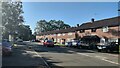
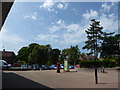
Priestwood Avenue
Terrace housing in Priestwood, Bracknell
Image: © James Emmans
Taken: 16 Jun 2021
0.07 miles
5
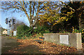
Queensway. 1953
"E II R QUEENSWAY 2 June 1953" says the stone.
A coronation memento from the beginning of a long reign. It's beside a footpath through a strip of parkland off Moordale Avenue.
Image: © Des Blenkinsopp
Taken: 25 Nov 2022
0.19 miles
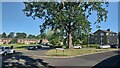
6
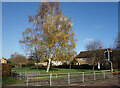
Coppice Green Bracknell
A small patch of grass and trees between the houses.
Image: © Des Blenkinsopp
Taken: 25 Nov 2022
0.22 miles