IMAGES TAKEN NEAR TO
RG41 4XQ
Introduction
This page details the photographs taken nearby to RG41 4XQ by members of the Geograph project.
The Geograph project started in 2005 with the aim of publishing, organising and preserving representative images for every square kilometre of Great Britain, Ireland and the Isle of Man.

There are currently over 7.5m images from over14,400 individuals and you can help contribute to the project by visiting https://www.geograph.org.uk
Image Map
Images are licensed for reuse under creativecommons.org/licenses/by-sa/2.0
Notes
- Clicking on the map will re-center to the selected point.
- The higher the marker number, the further away the image location is from the centre of the postcode.
Image Listing (9 Images Found)
Images are licensed for reuse under creativecommons.org/licenses/by-sa/2.0
Image
Details
Distance
1
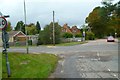
Looking across the B3349 from Doles Lane
Sandy Lane is on the other side.
Image: © Shazz
Taken: 17 Oct 2014
0.08 miles
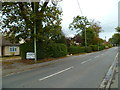
2
Sandy Lane looking towards Barkham Road
Image: © David Howard
Taken: 15 Jun 2015
0.09 miles
5
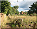
Footpath from Sandy Lane Byway
In the centre of the photo, but not easy to see, the public footpath leaves Sandy Lane here.
Image: © don cload
Taken: 11 Jun 2009
0.13 miles
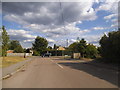
6
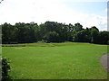
Half pitch
A small open space with only one goal post!
Image: © don cload
Taken: 11 Jun 2009
0.13 miles
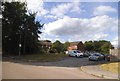
8
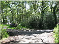
Clearing by the Footpath
A plot of empty land probably waiting for the builders to turn up, like so many plots of land round here.
Image: © Des Blenkinsopp
Taken: 10 Oct 2016
0.19 miles
9
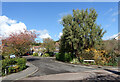
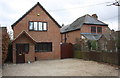
Cherry Tree Grove, Barkham
One of a neighbourhood of streets all with tree names.
Image: © Des Blenkinsopp
Taken: 13 Oct 2022
0.22 miles