IMAGES TAKEN NEAR TO
Durham Close, WOKINGHAM, RG41 3AB
Introduction
This page details the photographs taken nearby to Durham Close, RG41 3AB by members of the Geograph project.
The Geograph project started in 2005 with the aim of publishing, organising and preserving representative images for every square kilometre of Great Britain, Ireland and the Isle of Man.

There are currently over 7.5m images from over14,400 individuals and you can help contribute to the project by visiting https://www.geograph.org.uk
Image Map
Images are licensed for reuse under creativecommons.org/licenses/by-sa/2.0
Notes
- Clicking on the map will re-center to the selected point.
- The higher the marker number, the further away the image location is from the centre of the postcode.
Image Listing (12 Images Found)
Images are licensed for reuse under creativecommons.org/licenses/by-sa/2.0
Image
Details
Distance
1
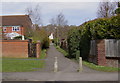
Pathway off Woosehill Road
This path leads into the northern part of the Woosehill estate.
Image: © john bristow
Taken: 14 Apr 2013
0.08 miles
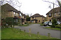
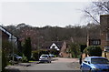
4
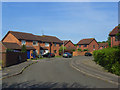
Culloden Way, Wokingham
A part of Woosehill where the roads are named after battles.
Image: © Andrew Smith
Taken: 11 May 2009
0.13 miles
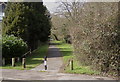
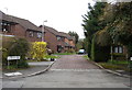
5
Hertford Close, Woosehill
One of a number of shared surface roads on this development.
Image: © john bristow
Taken: 13 Apr 2013
0.13 miles
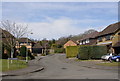
6
Jutland Close, Woosehill
One of the shared surface roads on this development.
Image: © john bristow
Taken: 13 Apr 2013
0.17 miles
9
Dorset Way (2)
This view shows the 'Mock Tudor' styling of the houses at the southern end of this road.
Image: © john bristow
Taken: 14 Apr 2013
0.21 miles
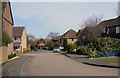
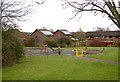
10
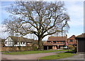
Sheridan Way, Woosehill
Thankfully this magnificent tree was preserved when the housing development took place.
Image: © john bristow
Taken: 14 Apr 2013
0.21 miles