IMAGES TAKEN NEAR TO
RG4 0EZ
Introduction
This page details the photographs taken nearby to RG4 0EZ by members of the Geograph project.
The Geograph project started in 2005 with the aim of publishing, organising and preserving representative images for every square kilometre of Great Britain, Ireland and the Isle of Man.

There are currently over 7.5m images from over14,400 individuals and you can help contribute to the project by visiting https://www.geograph.org.uk
Image Map
Images are licensed for reuse under creativecommons.org/licenses/by-sa/2.0
Notes
- Clicking on the map will re-center to the selected point.
- The higher the marker number, the further away the image location is from the centre of the postcode.
Image Listing (22 Images Found)
Images are licensed for reuse under creativecommons.org/licenses/by-sa/2.0
Image
Details
Distance
1
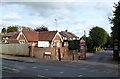
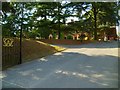
Lodge and Gates, Derby Road
This former gatehouse is now trading as The Thames Valley Clinic.
Image: © Des Blenkinsopp
Taken: 7 Oct 2013
0.08 miles
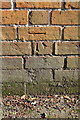
2
Benchmark on #14 Peppard Road
Ordnance Survey cut mark benchmark described on the Bench Mark Database at http://www.bench-marks.org.uk/bm28840
Image: © Roger Templeman
Taken: 15 Mar 2014
0.08 miles
3
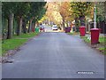
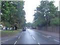
Derby Road, Caversham
A private road on bin-day.
Image: © Andrew Smith
Taken: 12 Nov 2007
0.08 miles
4
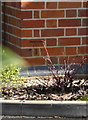
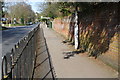
#14 Peppard Road
There is an OS benchmark Image on the front of the house at the left hand corner
Image: © Roger Templeman
Taken: 15 Mar 2014
0.09 miles
6
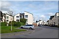
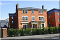
Field View, Caversham
A new development off Derby Road.
A slightly disingenuous street name here. There is indeed a view of a field. It's a school playing field, just behind the blocks on the right.
Image: © Des Blenkinsopp
Taken: 7 Oct 2013
0.10 miles
8
Peppard Road
There is an OS benchmark Image on the wall at the right hand edge of the image
Image: © Roger Templeman
Taken: 15 Mar 2014
0.13 miles
9
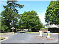
Newlands Avenue
Newlands Avenue is a residential street consisting mainly of detached and semi detached houses. It is a dead end that runs north west off Peppard Rd whose junction can be seen here.
Image: © Nigel Mykura
Taken: 27 Jul 2014
0.13 miles
10
Benchmark on wall on SE side of Peppard Road
Ordnance Survey cut mark benchmark described on the Bench Mark Database at http://www.bench-marks.org.uk/bm28853
Image: © Roger Templeman
Taken: 15 Mar 2014
0.14 miles