IMAGES TAKEN NEAR TO
Beaver Place, WOKINGHAM, RG40 5AN
Introduction
This page details the photographs taken nearby to Beaver Place, RG40 5AN by members of the Geograph project.
The Geograph project started in 2005 with the aim of publishing, organising and preserving representative images for every square kilometre of Great Britain, Ireland and the Isle of Man.

There are currently over 7.5m images from over14,400 individuals and you can help contribute to the project by visiting https://www.geograph.org.uk
Image Map
Images are licensed for reuse under creativecommons.org/licenses/by-sa/2.0
Notes
- Clicking on the map will re-center to the selected point.
- The higher the marker number, the further away the image location is from the centre of the postcode.
Image Listing (19 Images Found)
Images are licensed for reuse under creativecommons.org/licenses/by-sa/2.0
Image
Details
Distance
1
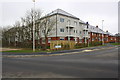
New housing on north edge of Wokingham
The new road carries the name Diamond Jubilee Way
Image: © Roger Templeman
Taken: 9 Mar 2015
0.08 miles

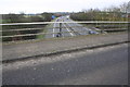
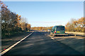
3

Keephatch Road, Wokingham
Approaching roundabout.
Image: © JThomas
Taken: 24 May 2022
0.12 miles
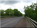
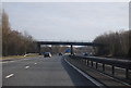
4
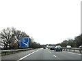
View of A329(M) from Warren House Road bridge
Image: © Roger Templeman
Taken: 9 Mar 2015
0.13 miles
7
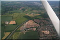
Keephatch, Wokingham: aerial 2016
Keephatch Park Nature Reserve adjoins the tip of the building site.
Image: © Chris
Taken: 10 Jun 2016
0.14 miles
8

Houses on Readwin Crescent
New housing development.
Image: © JThomas
Taken: 24 May 2022
0.16 miles