IMAGES TAKEN NEAR TO
RG3 6GR
Introduction
This page details the photographs taken nearby to RG3 6GR by members of the Geograph project.
The Geograph project started in 2005 with the aim of publishing, organising and preserving representative images for every square kilometre of Great Britain, Ireland and the Isle of Man.

There are currently over 7.5m images from over14,400 individuals and you can help contribute to the project by visiting https://www.geograph.org.uk
Image Map
Images are licensed for reuse under creativecommons.org/licenses/by-sa/2.0
Notes
- Clicking on the map will re-center to the selected point.
- The higher the marker number, the further away the image location is from the centre of the postcode.
Image Listing (21 Images Found)
Images are licensed for reuse under creativecommons.org/licenses/by-sa/2.0
Image
Details
Distance
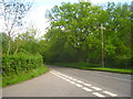
1
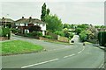
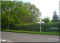
Dark Lane
Looking east towards Reading. Tilling Close is on your left, Highworth Way on you right.
Image: © Rosalind Mitchell
Taken: 12 May 2005
0.11 miles
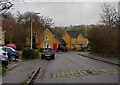
2
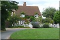
Cartwheel Cottage
Once an isolated farm cottage, now virtually attached to the suburbs of Tilehurst, just off to the right, but no doubt a desirable residence.
Image: © Graham Horn
Taken: 20 Jul 2008
0.12 miles
3
Blackthorn Close, Tilehurst
Houses on Tilehurst's western edge. To their west are the woods and farmland of Sulham.
Image: © Andrew Smith
Taken: 28 Mar 2008
0.12 miles
4
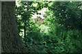
Stoneham Farm
The beginning of the countryside proper seen through the gap in the hedge that keeps Reading's suburbs in.
Image: © Rosalind Mitchell
Taken: 12 May 2005
0.12 miles
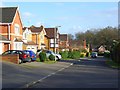
5
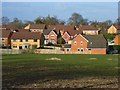
Tilehurst suburbia
Housing on the western edge of Reading's built up area but well like many of its suburbs this is outside of the official boundary. View across a field grazed by horses from the southern end of Long Lane.
Image: © Andrew Smith
Taken: 28 Mar 2008
0.14 miles
7
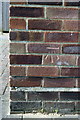
Benchmark on #26 Dark Lane
Ordnance Survey cut mark benchmark described on the Bench Mark Database at http://www.bench-marks.org.uk/bm42038
Image: © Roger Templeman
Taken: 21 Mar 2012
0.17 miles
10
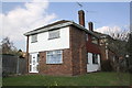
#26 Dark Lane
The house is in a semidetached pair with #156 Fairford Road. There is an OS benchmark Image on the facing corner of the house.
Image: © Roger Templeman
Taken: 21 Mar 2012
0.18 miles