IMAGES TAKEN NEAR TO
RG3 4SS
Introduction
This page details the photographs taken nearby to RG3 4SS by members of the Geograph project.
The Geograph project started in 2005 with the aim of publishing, organising and preserving representative images for every square kilometre of Great Britain, Ireland and the Isle of Man.

There are currently over 7.5m images from over14,400 individuals and you can help contribute to the project by visiting https://www.geograph.org.uk
Image Map
Images are licensed for reuse under creativecommons.org/licenses/by-sa/2.0
Notes
- Clicking on the map will re-center to the selected point.
- The higher the marker number, the further away the image location is from the centre of the postcode.
Image Listing (18 Images Found)
Images are licensed for reuse under creativecommons.org/licenses/by-sa/2.0
Image
Details
Distance
1
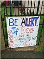
Sign on Teviot Road
A sign fixed to a gate to inform passers-by of a biting dog. It reads "BE ALERT If DOG ARE iN GaRDEN *DO NOT* *ENTER* DOG *BITE'S*", with "NHS" to the left.
Image: © Oscar Taylor
Taken: 2 Feb 2021
0.06 miles
2
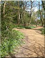
Path through Blundell's Copse
Blundell's Copse is a local nature reserve surrounded by urban Tilehurst.
Recent restoration work has been done on the paths.
Image: © Des Blenkinsopp
Taken: 10 Apr 2014
0.10 miles
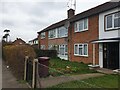
3
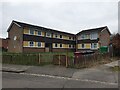
102-104 Corwen Road
A block of flats on Corwen Road, viewed from Ogmore Close. They were built in the 1970s.
Image: © Oscar Taylor
Taken: 3 Mar 2023
0.12 miles
4
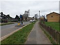
Traffic calming on Corwen Road
Looking north west on Corwen Road past a traffic calming measure: there are several on this road to prevent it being used as a shortcut. They are often flattened by drivers not paying attention and driving straight through them.
Image: © Oscar Taylor
Taken: 3 Mar 2023
0.13 miles
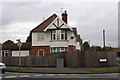
5
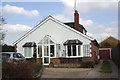
#111 St Michael's Road
There is an OS benchmark Image on the right side of the bungalow.
Image: © Roger Templeman
Taken: 21 Mar 2012
0.15 miles
6
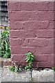
Rendered-over benchmark on #111 St Michael's Road
Ordnance Survey cut mark benchmark described on the Bench Mark Database at http://www.bench-marks.org.uk/bm42149
Image: © Roger Templeman
Taken: 21 Mar 2012
0.15 miles
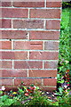
7
#326 The Meadway
There is an OS benchmark Image on the corner of the house
Image: © Roger Templeman
Taken: 4 Nov 2011
0.15 miles
8
Benchmark on #326 The Meadway
Ordnance Survey cut mark benchmark described on the Bench Mark Database at http://www.bench-marks.org.uk/bm40222
Image: © Roger Templeman
Taken: 4 Nov 2011
0.15 miles
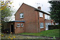
9
304-310a The Meadway
A long and thin block of flats on The Meadway in Tilehurst. Like most of the buildings along the road, they were built in the 1960s.
Image: © Oscar Taylor
Taken: 3 Mar 2023
0.16 miles
10
#348 The Meadway
The house is at the junction with St Michaels Road and has an OS benchmark Image
Image: © Roger Templeman
Taken: 4 Nov 2011
0.17 miles