IMAGES TAKEN NEAR TO
RG3 4LX
Introduction
This page details the photographs taken nearby to RG3 4LX by members of the Geograph project.
The Geograph project started in 2005 with the aim of publishing, organising and preserving representative images for every square kilometre of Great Britain, Ireland and the Isle of Man.

There are currently over 7.5m images from over14,400 individuals and you can help contribute to the project by visiting https://www.geograph.org.uk
Image Map
Images are licensed for reuse under creativecommons.org/licenses/by-sa/2.0
Notes
- Clicking on the map will re-center to the selected point.
- The higher the marker number, the further away the image location is from the centre of the postcode.
Image Listing (21 Images Found)
Images are licensed for reuse under creativecommons.org/licenses/by-sa/2.0
Image
Details
Distance
1
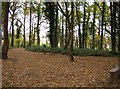
Lousehill Copse
A band of green within the Reading estates is well used by the local community and offers very pleasant woodland walks just a few minutes from many homes.
Image: © Graham Horn
Taken: 10 Nov 2007
0.05 miles
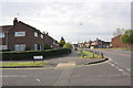
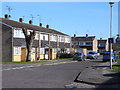
2
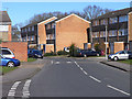
Elvaston Way, Reading
The junction with Poole Close is in the foreground.
Image: © Andrew Smith
Taken: 2 Mar 2010
0.07 miles
3
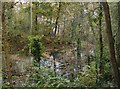
Pond in Lousehill Copse
Lousehill Copse is a band of green between two areas of poorer estate housing to the west of Reading. The local community takes pride in the Copse and has regular tidy-ups and events.
Image: © Graham Horn
Taken: 10 Nov 2007
0.09 miles
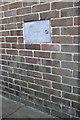
4
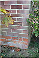
Benchmark on #26 Dee Road (Tern Close face)
Ordnance Survey cut mark benchmark described on the Bench Mark Database at http://www.bench-marks.org.uk/bm39881
Image: © Roger Templeman
Taken: 24 Oct 2011
0.15 miles
5
#26 Dee Road at junction with Tern Close
On the corner of the house is an OS benchmark Image
Image: © Roger Templeman
Taken: 24 Oct 2011
0.15 miles
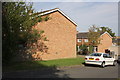
6
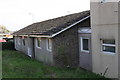
#22 Tay Road
As can be seen in the background, there is much housing development nearby - I wonder if this bungalow is due for demolition? On the far wall of the bungalow is an OS benchmark Image
Image: © Roger Templeman
Taken: 24 Oct 2011
0.15 miles
7
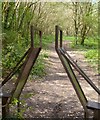
A Weird Sort of Gate
On many occasions as I squeeze my reasonably average sized self through pointlessly narrow gates and gaps I have wondered why footpath makers are so prejudiced against fat people.
But here it seems that their discriminations have been extended to those of us with sticky-out ears as well.
And ladies in big hats come to that.....
This is on Lousehill Copse local nature reserve.
Update:- I see this has made it onto the Humour in Descriptions forum, with a suggestion that it's for Daleks only.....nice one.
Image: © Des Blenkinsopp
Taken: 10 Apr 2014
0.15 miles
8
Benchmark on the side of #22 Tay Road
Ordnance Survey cut mark benchmark described on the Bench Mark Database at http://www.bench-marks.org.uk/bm39878
Image: © Roger Templeman
Taken: 24 Oct 2011
0.16 miles
9
Combe Road, Reading
Hardwick Road goes off to the left at this point.
Image: © Andrew Smith
Taken: 2 Mar 2010
0.17 miles
10
#1 Eskin Close
On the corner of the house under the tree is an OS benchmark Image
Image: © Roger Templeman
Taken: 24 Oct 2011
0.18 miles