IMAGES TAKEN NEAR TO
Broomfield Road, READING, RG30 6AL
Introduction
This page details the photographs taken nearby to Broomfield Road, RG30 6AL by members of the Geograph project.
The Geograph project started in 2005 with the aim of publishing, organising and preserving representative images for every square kilometre of Great Britain, Ireland and the Isle of Man.

There are currently over 7.5m images from over14,400 individuals and you can help contribute to the project by visiting https://www.geograph.org.uk
Image Map
Images are licensed for reuse under creativecommons.org/licenses/by-sa/2.0
Notes
- Clicking on the map will re-center to the selected point.
- The higher the marker number, the further away the image location is from the centre of the postcode.
Image Listing (26 Images Found)
Images are licensed for reuse under creativecommons.org/licenses/by-sa/2.0
Image
Details
Distance
2
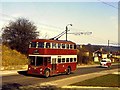
A trolleybus for Tilehurst climbing Norcot Road
A Reading Corporation trolleybus bound for Tilehurst climbs Norcot Road.
Image: © Richard Green
Taken: 27 Mar 1968
0.11 miles
3
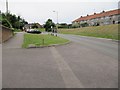
Romany Lane, Reading
The junction with Romany Close is in the foreground.
Image: © Andrew Smith
Taken: 16 Mar 2009
0.13 miles
4
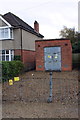
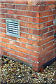
Electricity substation and #190 Norcot Road
To the right of the right hand side ventilation grill in an OS benchmark Image
Image: © Roger Templeman
Taken: 4 Nov 2011
0.15 miles
5
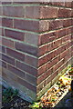
Benchmark on electricity substation, Norcot Road
Ordnance Survey cut mark benchmark described on the Bench Mark Database at http://www.bench-marks.org.uk/bm39942
Image: © Roger Templeman
Taken: 4 Nov 2011
0.15 miles
6
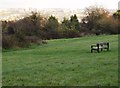
Watching Reading at McIlroy Park
If you thought you were going to see a picture of a football match, sorry to disappoint you. This is a seat in McIlroy Park, up on the Tilehurst ridge between the rivers Kennet and Thames. The view east is towards Reading town centre. On a clearer day you get a good interpretation of the geography of the town from up here.
Image: © Graham Horn
Taken: 10 Nov 2007
0.16 miles
7
Benchmark on #1 Brockley Close
Ordnance Survey cut mark benchmark described on the Bench Mark Database at http://www.bench-marks.org.uk/bm39855
Image: © Roger Templeman
Taken: 24 Oct 2011
0.17 miles
8
#1 Brockley Close
Behind the grey wheelie bin is an OS benchmark Image
Image: © Roger Templeman
Taken: 24 Oct 2011
0.17 miles
9
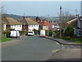
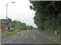
Looking up Norcot Road
View up Norcot road from by the cemetery.
Image: © Bill Nicholls
Taken: 23 Jun 2012
0.18 miles
10
Norcott Road junction with Pottery Road
There is a 6 foot 6 inch width restriction at this junction to prevent larger vehicles going down the hill towards the A329.
Image: © Stuart Logan
Taken: 17 Sep 2013
0.19 miles