IMAGES TAKEN NEAR TO
Poplar Avenue, READING, RG30 4JH
Introduction
This page details the photographs taken nearby to Poplar Avenue, RG30 4JH by members of the Geograph project.
The Geograph project started in 2005 with the aim of publishing, organising and preserving representative images for every square kilometre of Great Britain, Ireland and the Isle of Man.

There are currently over 7.5m images from over14,400 individuals and you can help contribute to the project by visiting https://www.geograph.org.uk
Image Map
Images are licensed for reuse under creativecommons.org/licenses/by-sa/2.0
Notes
- Clicking on the map will re-center to the selected point.
- The higher the marker number, the further away the image location is from the centre of the postcode.
Image Listing (35 Images Found)
Images are licensed for reuse under creativecommons.org/licenses/by-sa/2.0
Image
Details
Distance
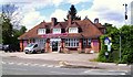
1
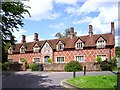
Mary Lyne's Almshouses
This fine terrace of almshouses is at the heart of the New Lane Hill conservation area.
British History Online says this:-
"Mary Lyne's Almshouses.
—In 1851, by indenture dated 11 January (enrolled), Mary Lyne gave a piece of land, on which she erected six cottages to be used as almshouses, which the founder endowed with £4,000 consols. The inmates were to be chosen, three from the parish of Burghfield and three from the parish of Tilehurst, and were to be widows without encumbrances, or unmarried, of sixty years or upwards belonging to the Church of England and of respectable character. The endowment now consists of £4,940 16s. 6d. with the official trustees (including a gift in 1884 by the Rev. John William Routh of £200 consols), producing an income of £123 10s. 4d. Each inmate receives an allowance of 5s. a week with an additional 30s. a year for clothing, three-quarters of a ton of coal, and is expected to attend divine service regularly."
Image: © Des Blenkinsopp
Taken: 5 May 2014
0.02 miles
2
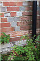
Benchmark on Mary Lyne Almshouses, New Lane Hill
Ordnance Survey cut mark benchmark described on the Bench Mark Database at http://www.bench-marks.org.uk/bm40227
Image: © Roger Templeman
Taken: 18 Nov 2011
0.03 miles
3
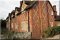
Mary Lyne Almshouses, New Lane Hill
There is an OS benchmark Image on the front corner of the nearest house
Image: © Roger Templeman
Taken: 18 Nov 2011
0.03 miles
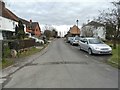
4
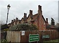
Houses on the corner of Greenwood Road and Poplar Avenue
Image: © David Howard
Taken: 6 Mar 2016
0.04 miles
7
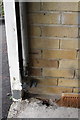
Benchmark in garage of #28 New Lane Hill
Ordnance Survey cut mark benchmark described on the Bench Mark Database at http://www.bench-marks.org.uk/bm40226
Image: © Roger Templeman
Taken: 18 Nov 2011
0.08 miles
8
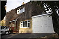
#28 New Lane Hill
There is an OS benchmark Image inside the garage, presumably cut on the side of the house before garage was added.
Image: © Roger Templeman
Taken: 18 Nov 2011
0.08 miles
9
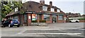
Welcome vets, north side Bath Road at New Lane Hill junction
Image: © Luke Shaw
Taken: 9 May 2022
0.08 miles
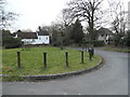
10
The Horncastle
Horncastle is the name of this area between Tilehurst, Southcote and Calcot.
Image: © Des Blenkinsopp
Taken: 5 May 2014
0.09 miles