IMAGES TAKEN NEAR TO
Wildmoor Lane, HOOK, RG27 0HH
Introduction
This page details the photographs taken nearby to Wildmoor Lane, RG27 0HH by members of the Geograph project.
The Geograph project started in 2005 with the aim of publishing, organising and preserving representative images for every square kilometre of Great Britain, Ireland and the Isle of Man.

There are currently over 7.5m images from over14,400 individuals and you can help contribute to the project by visiting https://www.geograph.org.uk
Image Map
Images are licensed for reuse under creativecommons.org/licenses/by-sa/2.0
Notes
- Clicking on the map will re-center to the selected point.
- The higher the marker number, the further away the image location is from the centre of the postcode.
Image Listing (3 Images Found)
Images are licensed for reuse under creativecommons.org/licenses/by-sa/2.0
Image
Details
Distance
1
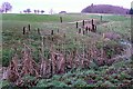
Bulrushes on the golf course
The landscaping of the golf course has created some little streams, planted with bulrushes, that are not marked on the map.
Image: © Graham Horn
Taken: 11 Dec 2008
0.14 miles
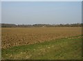
3
Looking towards Ducketts Farm
View from the public footpath which runs south of Moulshay Farm.
Image: © Mr Ignavy
Taken: 21 Mar 2009
0.24 miles