IMAGES TAKEN NEAR TO
Irvine Crescent, BASINGSTOKE, RG24 9TS
Introduction
This page details the photographs taken nearby to Irvine Crescent, RG24 9TS by members of the Geograph project.
The Geograph project started in 2005 with the aim of publishing, organising and preserving representative images for every square kilometre of Great Britain, Ireland and the Isle of Man.

There are currently over 7.5m images from over14,400 individuals and you can help contribute to the project by visiting https://www.geograph.org.uk
Image Map
Images are licensed for reuse under creativecommons.org/licenses/by-sa/2.0
Notes
- Clicking on the map will re-center to the selected point.
- The higher the marker number, the further away the image location is from the centre of the postcode.
Image Listing (102 Images Found)
Images are licensed for reuse under creativecommons.org/licenses/by-sa/2.0
Image
Details
Distance
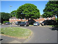
1
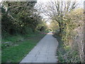
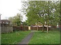
Footpath linking Shakespeare Road and Popley Way
Image: © Mr Ignavy
Taken: 7 Apr 2008
0.01 miles
2
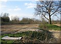
Rubble from John Hunt School
The school has been rebuilt nearby, within a couple of months the old school had gone. The land is now ready for more homes to be built upon.
Image: © Mr Ignavy
Taken: 7 Apr 2008
0.01 miles
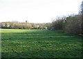
3
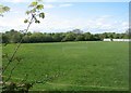
No match today
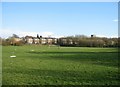
Playing field off Shakespeare Road.
Image: © Mr Ignavy
Taken: 26 Apr 2009
0.02 miles
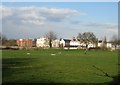
4
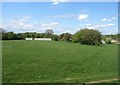
Playing Field
Once part of John Hunt School which had moved a year before this photo was taken. The school was demolished and turned into more houses. So much for keeping open spaces in high density residential areas in Basingstoke.
Image: © Mr Ignavy
Taken: 26 Apr 2009
0.03 miles
7
Open land & new housing
In no time at all the former John Hunt School site has been cleared and new housing built.
Image: © Mr Ignavy
Taken: 7 Apr 2008
0.06 miles
8
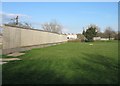
Boundary fence - former school site
Builders have put up this fence around the site of John Hunt School which has now been demolished. New buildings are already evident in the background.
Image: © Mr Ignavy
Taken: 7 Apr 2008
0.06 miles
9
Former school playing fields
Part of John Hunt Community School.
Image: © Mr Ignavy
Taken: 7 Apr 2008
0.07 miles
10
Path to Pershore Road
Leading away from a large area of open land.
Image: © Mr Ignavy
Taken: 23 Apr 2009
0.07 miles