IMAGES TAKEN NEAR TO
Priestley Road, BASINGSTOKE, RG24 9GZ
Introduction
This page details the photographs taken nearby to Priestley Road, RG24 9GZ by members of the Geograph project.
The Geograph project started in 2005 with the aim of publishing, organising and preserving representative images for every square kilometre of Great Britain, Ireland and the Isle of Man.

There are currently over 7.5m images from over14,400 individuals and you can help contribute to the project by visiting https://www.geograph.org.uk
Image Map
Images are licensed for reuse under creativecommons.org/licenses/by-sa/2.0
Notes
- Clicking on the map will re-center to the selected point.
- The higher the marker number, the further away the image location is from the centre of the postcode.
Image Listing (272 Images Found)
Images are licensed for reuse under creativecommons.org/licenses/by-sa/2.0
Image
Details
Distance
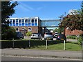
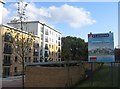
1
Vickers House & Millennium House
Office blocks on Priestley Road.
Image: © Fernweh
Taken: 17 Jul 2017
0.01 miles
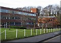
5
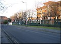
Priestly Road
Late afternoon sun in winter.
Image: © Mr Ignavy
Taken: 23 Jan 2009
0.04 miles
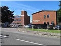
7
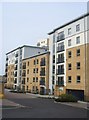
New apartment block
Close to North Hants Hospital. Similar to many such developments in and around Basingstoke - expensive to rent, small rooms and small windows. Still we have to live somewhere.
Image: © Mr Ignavy
Taken: 23 Apr 2009
0.04 miles
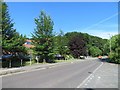
9
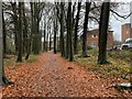
A few surviving trees
Close to the hospital, much of the open land has now been built on during the past 10 years.
Image: © Fernweh
Taken: 16 Aug 2012
0.05 miles