IMAGES TAKEN NEAR TO
Abbey Road, BASINGSTOKE, RG24 9EP
Introduction
This page details the photographs taken nearby to Abbey Road, RG24 9EP by members of the Geograph project.
The Geograph project started in 2005 with the aim of publishing, organising and preserving representative images for every square kilometre of Great Britain, Ireland and the Isle of Man.

There are currently over 7.5m images from over14,400 individuals and you can help contribute to the project by visiting https://www.geograph.org.uk
Image Map
Images are licensed for reuse under creativecommons.org/licenses/by-sa/2.0
Notes
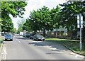
- Clicking on the map will re-center to the selected point.
- The higher the marker number, the further away the image location is from the centre of the postcode.
Image Listing (149 Images Found)
Images are licensed for reuse under creativecommons.org/licenses/by-sa/2.0
Image
Details
Distance
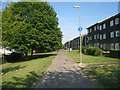
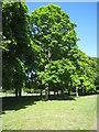
2
Flats along Melrose Walk
Residents on this side have the small benefit of overlooking this open ground as well as the local infant school playing fields.
Image: © Mr Ignavy
Taken: 3 May 2011
0.06 miles
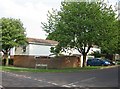
5
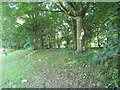
Trees on the embankment
Providing a bit of a screne from the traffic noise on the ring road.
Image: © Mr Ignavy
Taken: 10 May 2011
0.07 miles
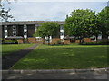
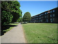
8
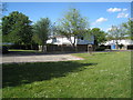
Space within the estate
Abbey Road, Popley, Basingstoke.
Image: © Mr Ignavy
Taken: 10 May 2011
0.07 miles
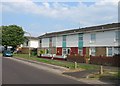
9
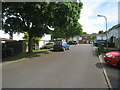
Residential street - Popley
Part of Abbey Road.
Image: © Mr Ignavy
Taken: 16 May 2011
0.08 miles