IMAGES TAKEN NEAR TO
Merryfield, BASINGSTOKE, RG24 8XW
Introduction
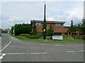
This page details the photographs taken nearby to Merryfield, RG24 8XW by members of the Geograph project.
The Geograph project started in 2005 with the aim of publishing, organising and preserving representative images for every square kilometre of Great Britain, Ireland and the Isle of Man.

There are currently over 7.5m images from over14,400 individuals and you can help contribute to the project by visiting https://www.geograph.org.uk
Image Map
Images are licensed for reuse under creativecommons.org/licenses/by-sa/2.0
Notes
- Clicking on the map will re-center to the selected point.
- The higher the marker number, the further away the image location is from the centre of the postcode.
Image Listing (43 Images Found)
Images are licensed for reuse under creativecommons.org/licenses/by-sa/2.0
Image
Details
Distance
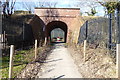
1

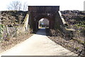
Footpath under the railway
The railway line from Basingstoke to Reading separates the residential area of Chineham from Chineham Business Park. This footpath leads from Lime Tree Way in the business park to Hanmore Road (which can be seen in the photograph) through a short tunnel under the railway line.
Image: © Euchiasmus
Taken: 16 Feb 2008
0.13 miles