IMAGES TAKEN NEAR TO
Swing Swang Lane, BASINGSTOKE, RG24 8NR
Introduction
This page details the photographs taken nearby to Swing Swang Lane, RG24 8NR by members of the Geograph project.
The Geograph project started in 2005 with the aim of publishing, organising and preserving representative images for every square kilometre of Great Britain, Ireland and the Isle of Man.

There are currently over 7.5m images from over14,400 individuals and you can help contribute to the project by visiting https://www.geograph.org.uk
Image Map
Images are licensed for reuse under creativecommons.org/licenses/by-sa/2.0
Notes
- Clicking on the map will re-center to the selected point.
- The higher the marker number, the further away the image location is from the centre of the postcode.
Image Listing (197 Images Found)
Images are licensed for reuse under creativecommons.org/licenses/by-sa/2.0
Image
Details
Distance
1
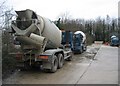
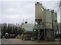
Ready-mix concrete mixers on their day off
At a ready-mix plant owned by Premix.
Image: © Mr Ignavy
Taken: 20 Jan 2008
0.03 miles
3
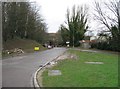
Faraday Road
Looking towards Daneshill roundabout.
Image: © Mr Ignavy
Taken: 14 May 2011
0.04 miles
4
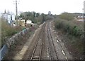
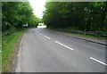
Reading to Basingstoke
View from the Faraday Road bridge.
Image: © Mr Ignavy
Taken: 20 Jan 2008
0.04 miles
5
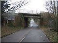
Bridge repairs
Swing Swang Lane - Reading line passes overhead.
Image: © Mr Ignavy
Taken: 18 Jan 2009
0.04 miles
7
Ready-mix concrete plant - Swing Swang Lane
Image: © Mr Ignavy
Taken: 20 Jan 2008
0.04 miles
8
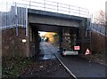
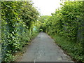
Swing Swang Lane becomes a footpath
View from the end of the lane. Now closed off to traffic this route under the railway links with Rankine Road.
Image: © Mr Ignavy
Taken: 20 Jan 2008
0.05 miles
9
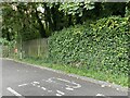
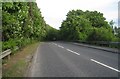
Cycleway behind Daneshill Industrial Estate
Image: © Mr Ignavy
Taken: 25 May 2008
0.05 miles