IMAGES TAKEN NEAR TO
Oakridge Road, BASINGSTOKE, RG21 5SQ
Introduction
This page details the photographs taken nearby to Oakridge Road, RG21 5SQ by members of the Geograph project.
The Geograph project started in 2005 with the aim of publishing, organising and preserving representative images for every square kilometre of Great Britain, Ireland and the Isle of Man.

There are currently over 7.5m images from over14,400 individuals and you can help contribute to the project by visiting https://www.geograph.org.uk
Image Map
Images are licensed for reuse under creativecommons.org/licenses/by-sa/2.0
Notes
- Clicking on the map will re-center to the selected point.
- The higher the marker number, the further away the image location is from the centre of the postcode.
Image Listing (406 Images Found)
Images are licensed for reuse under creativecommons.org/licenses/by-sa/2.0
Image
Details
Distance
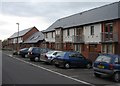
4
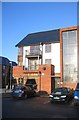
Early morning light
Key worker housing in Oakridge by the Oak Pub.
Image: © Mr Ignavy
Taken: 4 Mar 2009
0.01 miles
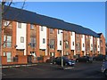
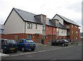
5
Jefferson Road
New housing at the end close to Oakridge Road.
Image: © Mr Ignavy
Taken: 25 Mar 2008
0.01 miles
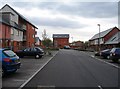
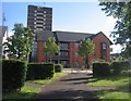
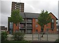
8
Pear Tree Way & Oakridge Tower
New flats and an old local landmark.
Image: © Mr Ignavy
Taken: 15 May 2008
0.01 miles
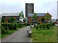
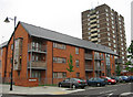
9
New homes, old tower block
Housing in Oakridge.
Image: © Fernweh
Taken: 5 May 2015
0.01 miles
