
IMAGES TAKEN NEAR TO
Basingstoke Road, READING, RG2 0SJ
Introduction
This page details the photographs taken nearby to Basingstoke Road, RG2 0SJ by members of the Geograph project.
The Geograph project started in 2005 with the aim of publishing, organising and preserving representative images for every square kilometre of Great Britain, Ireland and the Isle of Man.

There are currently over 7.5m images from over14,400 individuals and you can help contribute to the project by visiting https://www.geograph.org.uk
Image Map
Images are licensed for reuse under creativecommons.org/licenses/by-sa/2.0
Notes
- Clicking on the map will re-center to the selected point.
- The higher the marker number, the further away the image location is from the centre of the postcode.
Image Listing (30 Images Found)
Images are licensed for reuse under creativecommons.org/licenses/by-sa/2.0
Image
Details
Distance
1
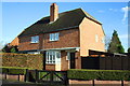
Semi-detached houses on Ambrook Road
There is an OS benchmark Image on the side of the near house at its front corner where the wooden gate abuts
Image: © Roger Templeman
Taken: 14 Jan 2014
0.06 miles
2
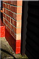
Benchmark on #62 Ambrook Road
Ordnance Survey cut mark benchmark described on the Bench Mark Database at http://www.bench-marks.org.uk/bm53842
Image: © Roger Templeman
Taken: 14 Jan 2014
0.06 miles
3

St Paul's Church, Whitley
Not a very good shot I'm afraid, with all the cars and building work, but this little mission hall style church is still used for regular worship, and as a play centre during the week.
Image: © Des Blenkinsopp
Taken: 13 Nov 2013
0.09 miles
4

Whitley Hall, Basingstoke Road
There is an OS benchmark Image on the left hand corner of this former school house, now flats
Image: © Roger Templeman
Taken: 14 Jan 2014
0.10 miles
5

Benchmark on Whitley Hall
Ordnance Survey cut mark benchmark described on the Bench Mark Database at http://www.bench-marks.org.uk/bm25705
Image: © Roger Templeman
Taken: 14 Jan 2014
0.10 miles
6
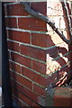
Benchmark on #535 Basingstoke Road
Ordnance Survey cut mark benchmark described on the Bench Mark Database at http://www.bench-marks.org.uk/bm53844
Image: © Roger Templeman
Taken: 14 Jan 2014
0.10 miles
7
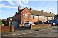
Row of houses on Basingstoke Road
There is an OS benchmark Image on the side of the near house, behind the black wheelie bin
Image: © Roger Templeman
Taken: 14 Jan 2014
0.10 miles
8

An Unusual Building in Whitley
A remnant from before the development of Whitley as a Reading suburb, and now quite out of character with its surroundings.
It looks like almshouses or an old school or something.
Image: © Des Blenkinsopp
Taken: 13 Nov 2013
0.11 miles
9

Benchmark on brick building, St Pauls Mews
Ordnance Survey cut mark benchmark described on the Bench Mark Database at http://www.bench-marks.org.uk/bm53843
Image: © Roger Templeman
Taken: 14 Jan 2014
0.11 miles
