IMAGES TAKEN NEAR TO
Longcroft Road, THATCHAM, RG19 4QT
Introduction
This page details the photographs taken nearby to Longcroft Road, RG19 4QT by members of the Geograph project.
The Geograph project started in 2005 with the aim of publishing, organising and preserving representative images for every square kilometre of Great Britain, Ireland and the Isle of Man.

There are currently over 7.5m images from over14,400 individuals and you can help contribute to the project by visiting https://www.geograph.org.uk
Image Map
Images are licensed for reuse under creativecommons.org/licenses/by-sa/2.0
Notes
- Clicking on the map will re-center to the selected point.
- The higher the marker number, the further away the image location is from the centre of the postcode.
Image Listing (7 Images Found)
Images are licensed for reuse under creativecommons.org/licenses/by-sa/2.0
Image
Details
Distance
1
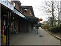
Thatcham: Station Road Post Office
The post office will close permanently on 2 April 2008, as part of the nationwide branch closure plan. It is set within a convenience store, meaning that this view will probably not change much, apart from the removal of the familiar oval sign, once the office closes.
Image: © Chris Downer
Taken: 15 Mar 2008
0.12 miles
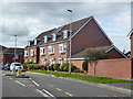
2
Observer Drive, Thatcham
A recent street in an expanding town.
Not a usual street name, but other roads nearby are named on a military theme.
Hussars, Dragoons, Horse Guards, Lancers, to name some of them.
Might this be from the Observer Corps? Just a guess.
Image: © Des Blenkinsopp
Taken: 29 Feb 2016
0.13 miles
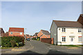
3
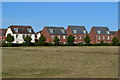
Houses on Urquhart Road, Thatcham
A large and relatively new housing development.
Image: © Robin Webster
Taken: 16 Sep 2017
0.13 miles
4
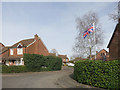
Flag on the Corner
Thompson Drive off Agricola Way.
Image: © Des Blenkinsopp
Taken: 29 Feb 2016
0.15 miles
5
Houses in Rotary Way, backing onto recreation ground
Image: © David Martin
Taken: 5 Aug 2018
0.22 miles
6
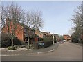
The Martins, Thatcham
One of the many residential no through roads which are the typical street plan for this area.
Image: © Des Blenkinsopp
Taken: 29 Feb 2016
0.23 miles
7
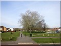
Moorside Park, Thatcham
A recreation ground surrounded by housing.
Image: © Des Blenkinsopp
Taken: 29 Feb 2016
0.24 miles