IMAGES TAKEN NEAR TO
Blenheim Place, Castle Street, READING, RG1 7ST
Introduction
This page details the photographs taken nearby to Blenheim Place, Castle Street, RG1 7ST by members of the Geograph project.
The Geograph project started in 2005 with the aim of publishing, organising and preserving representative images for every square kilometre of Great Britain, Ireland and the Isle of Man.

There are currently over 7.5m images from over14,400 individuals and you can help contribute to the project by visiting https://www.geograph.org.uk
Image Map
Images are licensed for reuse under creativecommons.org/licenses/by-sa/2.0
Notes
- Clicking on the map will re-center to the selected point.
- The higher the marker number, the further away the image location is from the centre of the postcode.
Image Listing (440 Images Found)
Images are licensed for reuse under creativecommons.org/licenses/by-sa/2.0
Image
Details
Distance
1
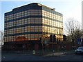
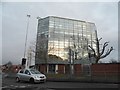
Castle Hill roundabout
This site on the south-east corner of the roundabout has been behind hoardings for a while. A new office block has been built on the site, or maybe it was the old one refurbished. The previous building on the site is this one Image] Is it the same building?
Image: © Graham Horn
Taken: 12 Jun 2009
0.01 miles

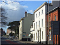
3
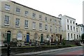
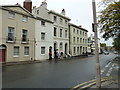
Castle Hill
The left hand side of Castle Hill, just west of the roundabout. The building numbers here, in the 150s, show that it was at one time an extension of Castle Street and the numbers are continuous from there. Many of the buildings are listed and it is a conservation area.
Image: © Graham Horn
Taken: 12 Jun 2009
0.02 miles
4
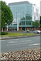
87 Castle Street, Reading
An office block belonging to Citi Financial beside a roundabout above the inner distribution road. The car is waiting to join the roundabout having descended Castle Street.
Image: © Andrew Smith
Taken: 2 Jan 2008
0.03 miles
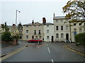
6
Castle Hill, Reading
On the right we have the red bricks of the Horse and Jockey pub, followed by Culham House and the junction with Carey Street. Thereafter the view leaves SU7173. The road is the A4155 and is seen here climbing up to the junction with Tilehurst Road. The rather grand houses mostly date from the earlier part of the 19th century. Most, if not all, of the buildings are listed.
Image: © Andrew Smith
Taken: 26 Feb 2008
0.04 miles
7
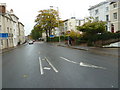
Approaching the junction of Castle Hill and Field Road
Image: © Basher Eyre
Taken: 31 Oct 2010
0.04 miles
8
Looking from Field Road into Castle Hill
Image: © Basher Eyre
Taken: 31 Oct 2010
0.04 miles
9
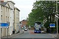
Castle Hill
Looking eastbound towards Reading town centre from halfway down the hill (I am standing on a traffic island dividing the carriageway). The four lane carriageway where I am standing narrows to three, and the red tarmac is a contraflow lane, inbound downhill in the morning peak periods (see the signs) and outbound towards us at other times. It works because at those times when it is needed the traffic runs slowly. The bus is on route 33 to Turnham's Farm, a western suburb of Reading. Since about 2006 the main routes in Reading have had colour coded buses, so if you are looking for a 33 you are looking for a blue bus (usually). The bus is just crossing the grid line.
Image: © Graham Horn
Taken: 12 Jun 2009
0.04 miles