IMAGES TAKEN NEAR TO
Hosier Street, READING, RG1 7QL
Introduction
This page details the photographs taken nearby to Hosier Street, RG1 7QL by members of the Geograph project.
The Geograph project started in 2005 with the aim of publishing, organising and preserving representative images for every square kilometre of Great Britain, Ireland and the Isle of Man.

There are currently over 7.5m images from over14,400 individuals and you can help contribute to the project by visiting https://www.geograph.org.uk
Image Map
Images are licensed for reuse under creativecommons.org/licenses/by-sa/2.0
Notes
- Clicking on the map will re-center to the selected point.
- The higher the marker number, the further away the image location is from the centre of the postcode.
Image Listing (991 Images Found)
Images are licensed for reuse under creativecommons.org/licenses/by-sa/2.0
Image
Details
Distance
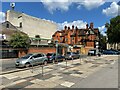
2
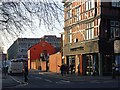
Hosier Street, Reading
Beside the market with the tower of St Mary's church ahead. The building on the left is now a pub called Pavlov's Dog.
Image: © Andrew Smith
Taken: 4 Oct 2007
0.01 miles
3
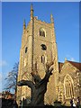
St Mary's church tower, Reading
The mid 16th century tower of Reading's minster church, chequered with flint and stone.
Image: © Andrew Smith
Taken: 2 Jan 2008
0.01 miles
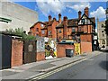
4
Hosier Street, Reading
Leading alongside the market from St Mary's Butts. The pub on the right is part of a well-known chain and occupies an old-looking building which isn't listed. The orange building is a bar and beyond is the concrete of the Broad Street Mall's car park.
Image: © Andrew Smith
Taken: 2 Jan 2008
0.01 miles
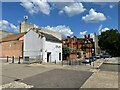
5
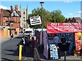
View east along Hosier Street
Note the market stall frames. See also Image
Image: © Fernweh
Taken: 3 Aug 2021
0.01 miles
6
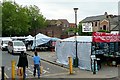
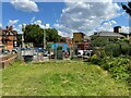
Hosier Street market
A market takes place here on three days a week. It always seems to be a bit tatty and run down.
Image: © Graham Horn
Taken: 12 Jun 2009
0.01 miles
9
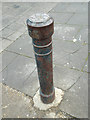
Foggy Reading ? cast iron bollard, Hosier Street
Beside a pedestrian ramp up to Dusseldorf Way. Note the hexagonal design on the top.
Image: © Robin Stott
Taken: 11 Dec 2013
0.02 miles
10
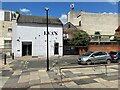
Once a nightclub
Information about this former nightclub on the "Get Reading" website provides a somewhat chequered history. I quote "A nightclub in Reading town centre which closed after years of problems with drugs and violence... The club closed in September (2017) after losing its licence due to two major police incidents and drug problems. The club, which has also been known as Bar Mango, Zeus Bar and Club 20, had a history of problems with crime. One incident was a mass brawl in July (2017) last year where a man was slashed with what police say was a weapon.
The final straw was an incident of mass disorder on in the early hours of Saturday, August 5, (2017) where St Mary's Butts had to be closed due to the trouble."
Image: © Fernweh
Taken: 3 Aug 2021
0.02 miles