IMAGES TAKEN NEAR TO
Stanley Grove, READING, RG1 7NS
Introduction
This page details the photographs taken nearby to Stanley Grove, RG1 7NS by members of the Geograph project.
The Geograph project started in 2005 with the aim of publishing, organising and preserving representative images for every square kilometre of Great Britain, Ireland and the Isle of Man.

There are currently over 7.5m images from over14,400 individuals and you can help contribute to the project by visiting https://www.geograph.org.uk
Image Map
Images are licensed for reuse under creativecommons.org/licenses/by-sa/2.0
Notes
- Clicking on the map will re-center to the selected point.
- The higher the marker number, the further away the image location is from the centre of the postcode.
Image Listing (182 Images Found)
Images are licensed for reuse under creativecommons.org/licenses/by-sa/2.0
Image
Details
Distance
1
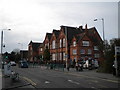
Reading
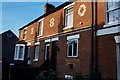
Characteristic decorative brickwork in Cambridge Street, north of Oxford Road (A329)
Image: © Rosalind Mitchell
Taken: Unknown
0.00 miles
3
The Queen Elizabeth, George Street
The pub had been closed for several years when this picture was taken - it had a reputation as something of a trouble spot. There is planning permission to convert the building into flats.
Image: © Rose and Trev Clough
Taken: 5 Dec 2014
0.04 miles
4
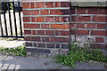
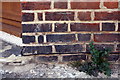
Benchmark on Oxford Road Primary School
Ordnance Survey cut mark benchmark described on the Bench Mark Database at http://www.bench-marks.org.uk/bm37676
Image: © Roger Templeman
Taken: 20 Apr 2011
0.04 miles
5
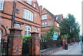
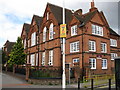
Oxford Road Primary School, Oxford Road, Reading
At the junction with George Street
Image: © Robin Sones
Taken: 24 Mar 2010
0.05 miles
6
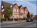
Oxford Road Primary School, Reading
Situated to the west of Reading town centre on the Oxford Road. The school opened in 1883 and is a Victorian two-storey building http://www.oxfordroad.reading.sch.uk/
Image: © Paul Gillett
Taken: 23 Mar 2012
0.05 miles
8
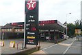
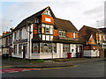
Texaco filling station, Oxford Road
They seem to have given up displaying the price of unleaded, but it would have been about 113.9 pence.
Image: © Graham Horn
Taken: 30 Sep 2008
0.06 miles
9
Benchmark on east face of #42 George Street
Ordnance Survey cut mark benchmark described on the Bench Mark Database at http://www.bench-marks.org.uk/bm37677
Image: © Roger Templeman
Taken: 20 Apr 2011
0.06 miles
10
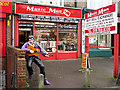
Elvis lives - down the Oxford Road
Outside a second-hand music shop called Music Man http://musicmanreading.co.uk/music/ .
Image: © Rose and Trev Clough
Taken: 5 Dec 2014
0.06 miles