IMAGES TAKEN NEAR TO
Glenbeigh Terrace, READING, RG1 6PB
Introduction
This page details the photographs taken nearby to Glenbeigh Terrace, RG1 6PB by members of the Geograph project.
The Geograph project started in 2005 with the aim of publishing, organising and preserving representative images for every square kilometre of Great Britain, Ireland and the Isle of Man.

There are currently over 7.5m images from over14,400 individuals and you can help contribute to the project by visiting https://www.geograph.org.uk
Image Map
Images are licensed for reuse under creativecommons.org/licenses/by-sa/2.0
Notes
- Clicking on the map will re-center to the selected point.
- The higher the marker number, the further away the image location is from the centre of the postcode.
Image Listing (288 Images Found)
Images are licensed for reuse under creativecommons.org/licenses/by-sa/2.0
Image
Details
Distance
1
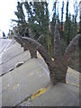
Anti-climb ironwork, Tilehurst Road Railway Bridge, Reading
Image: © Robin Sones
Taken: 24 Mar 2010
0.03 miles
2
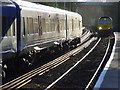
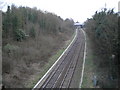
The railway at Reading West Station
Looking south from the station to the bridge on Tilehurst Road. The train on the left is a passenger service for Newbury. A goods train approaches.
Image: © Andrew Smith
Taken: 24 Jan 2008
0.04 miles
3
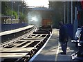
Reading West Station
A passenger service for Newbury passes under the bridge on Tilehurst Road as a goods train trundles by in the opposite direction.
Image: © Andrew Smith
Taken: 24 Jan 2008
0.04 miles
4
Tilehurst Road Bridge, Reading
With a description http://www.historicengland.org.uk/listing/the-list/list-entry/1409246 to match the A4 road bridge a little to the south, this carries a minor road through the suburbs. "Forms an impressive pair with the similar and contemporary Bath Road Bridge."
Image: © Derek Harper
Taken: 30 Sep 2015
0.04 miles
5
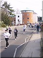
Reading half marathon
Reading half marathon is apparently the third most popular half marathon in the country. It is usually run about a month before the London marathon so is a good training event for that one. The route in West Reading via Russell Street, Tilehurst Road, Liebenrood Road, Bath Road and Coley Avenue means that part of Reading is cut off whilst it is on, so the only thing to do is to go and watch.
This is Tilehurst Road just before the railway bridge. The circular building in the background is a new block of flats called the Observatory. The top flat must be the one to have, if you like windows.
Image: © Graham Horn
Taken: 25 Mar 2007
0.04 miles
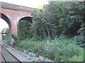
6
Tilehurst Road railway bridge
This brickwork has been repaired at various times, presumably as people have hit it to avoid an accident on the narrow bridge. We are 37 miles and 9 chains from London Paddington on the Basingstoke line.
Image: © Graham Horn
Taken: 30 Sep 2008
0.05 miles
7
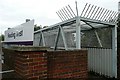
Reading West bridge
Adjacent to Tilehurst Road and the southern entrance to Reading West station is this pedestrian bridge over the Reading to Basingstoke railway line. It is enclosed, with spikes to discourage venturing onto its roof, presumably because it is so high above the railway line and would be a likely suicide point.
Image: © Graham Horn
Taken: 30 Sep 2008
0.05 miles
8
Looking south from the Tilehurst Road Railway Bridge
Image: © Robin Sones
Taken: 24 Mar 2010
0.06 miles
9

35 Tilehurst Road, Reading
35 Tilehurst Road is located on the corner of Brunswick Street and Tilehurst Road in Reading. Despite its street address, the house's principal frontage and front entrance, pictured here, are located on Brunswick Street.
Image: © Robin Sones
Taken: 24 Mar 2010
0.06 miles
10
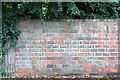
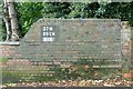
Rat trap bond
This wall is one of the original places that I saw rat trap bond. The bricks are laid on their sides in two parallel lines with a gap in between, and every fourth one is laid across the wall to provide a bond between the two halves. However there is a cavity in the middle where rats get trapped, hence the name. The bond is a way of building a reasonably strong wall with fewer bricks.
Image: © Graham Horn
Taken: 30 Sep 2008
0.06 miles