IMAGES TAKEN NEAR TO
Alexandra Road, READING, RG1 5PE
Introduction
This page details the photographs taken nearby to Alexandra Road, RG1 5PE by members of the Geograph project.
The Geograph project started in 2005 with the aim of publishing, organising and preserving representative images for every square kilometre of Great Britain, Ireland and the Isle of Man.

There are currently over 7.5m images from over14,400 individuals and you can help contribute to the project by visiting https://www.geograph.org.uk
Image Map
Images are licensed for reuse under creativecommons.org/licenses/by-sa/2.0
Notes
- Clicking on the map will re-center to the selected point.
- The higher the marker number, the further away the image location is from the centre of the postcode.
Image Listing (164 Images Found)
Images are licensed for reuse under creativecommons.org/licenses/by-sa/2.0
Image
Details
Distance
1
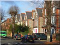
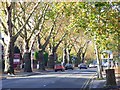
Alexandra Road, Reading
A road of large Victorian houses some of which have been converted into other uses (e.g. surgeries) or into multiple occupancy. It has an avenue of lime trees.
Image: © Andrew Smith
Taken: 24 Nov 2008
0.06 miles
2
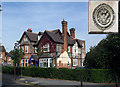
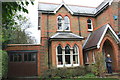
52 Erleigh Road
Already pictured and described by Andrew Smith in Image this is the Queen Victoria's Jubilee Institute for Nurses, still occupied by the NHS, together with an inset of the original plaque which you can see on the east face of the building.
It's a pity the obviously demolished extension on that side has been left in such a poorly finished off state.
Image: © Des Blenkinsopp
Taken: 23 Sep 2010
0.06 miles
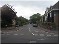
3
London Road at the junction of Alexandra Road
Image: © David Howard
Taken: 18 Feb 2019
0.07 miles

6
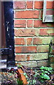
Benchmark on #21 Erleigh Road
Ordnance Survey cut mark benchmark described on the Bench Mark Database at http://www.bench-marks.org.uk/bm32539
Image: © Roger Templeman
Taken: 15 Jan 2014
0.08 miles
7
#21 Erleigh Road
There is an OS benchmark Image on the bricks at the right hand side of the garage at the junction with the house
Image: © Roger Templeman
Taken: 15 Jan 2014
0.08 miles
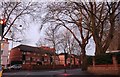
8
London Road, Reading
This is a stretch of the A4, which skirts just to the south of the town centre. However, all traffic into Reading from the east has to use this route as the nearby King's Road (A329) cannot be used in a westerly direction by vehicles other than buses, taxis and bikes. The traffic lights are at the foot of Alexandra Road. Most of the large houses along the road have been converted into flats or non-residential use (dentists, vets etc). On the left is the entrance to the Donnington House Hotel.
Image: © Andrew Smith
Taken: 6 Nov 2007
0.10 miles
9
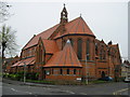
St.Luke's, Reading
Parish Church of St Luke's.
Image: © don cload
Taken: 15 Apr 2009
0.10 miles
10
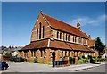
St Luke, Reading
Grade 2 listed building erected in 1882.
Image: © Michael FORD
Taken: Unknown
0.10 miles