IMAGES TAKEN NEAR TO
Erleigh Road, READING, RG1 5NB
Introduction
This page details the photographs taken nearby to Erleigh Road, RG1 5NB by members of the Geograph project.
The Geograph project started in 2005 with the aim of publishing, organising and preserving representative images for every square kilometre of Great Britain, Ireland and the Isle of Man.

There are currently over 7.5m images from over14,400 individuals and you can help contribute to the project by visiting https://www.geograph.org.uk
Image Map
Images are licensed for reuse under creativecommons.org/licenses/by-sa/2.0
Notes
- Clicking on the map will re-center to the selected point.
- The higher the marker number, the further away the image location is from the centre of the postcode.
Image Listing (93 Images Found)
Images are licensed for reuse under creativecommons.org/licenses/by-sa/2.0
Image
Details
Distance
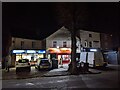
2
Co-op food shop on the corner of Erleigh Road and Blenheim Road, looking east
Image: © Rob Purvis
Taken: 7 Feb 2023
0.03 miles
3
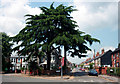
Corner of De Beauvoir Road
De Beauvoir Rd is another street of Victorian terrace houses so typical of this part of town.
It's that splendid tree that makes this view a bit different.
Image: © Des Blenkinsopp
Taken: 14 Jun 2010
0.04 miles
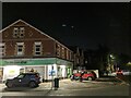
4
The Wash Box Launderette
I admit to liking brightly painted buildings, although some members of the Victorian Society might cringe at what's gone on here.
But just see the details of the brickwork and ornamentation on what is after all just a suburban end of terrace. The gables,chimneys, the corner window and even the single story bit at the side. Any excuse for a bit of flamboyance.
Reading has so much of this sort of stuff.
I wonder if this was a pub originally. I've tried to make out what's written on the wall under the chimney but it's too far gone.
Image: © Des Blenkinsopp
Taken: 13 Jun 2010
0.05 miles
5
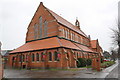
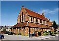
St Luke's Church, Erleigh Road
There is an OS benchmark Image on the buttress with the red notice on the near corner of the church
Image: © Roger Templeman
Taken: 15 Jan 2014
0.06 miles
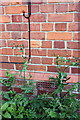
6
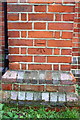
Benchmark on buttress of St Luke's Church
Ordnance Survey cut mark benchmark described on the Bench Mark Database at http://www.bench-marks.org.uk/bm32520
Image: © Roger Templeman
Taken: 15 Jan 2014
0.06 miles
7
St Luke, Reading
Grade 2 listed building erected in 1882.
Image: © Michael FORD
Taken: Unknown
0.06 miles
8
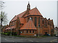
St.Luke's, Reading
Parish Church of St Luke's.
Image: © don cload
Taken: 15 Apr 2009
0.06 miles
9
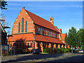
St Luke's, Reading
Built in 1882 in red-brick with a recently renewed red tile roof.
Image: © Andrew Smith
Taken: 21 Jul 2008
0.07 miles
10
Benchmark on chimney breast of #1 Junction Road
Ordnance Survey cut mark benchmark described on the Bench Mark Database at http://www.bench-marks.org.uk/bm39345
Image: © Roger Templeman
Taken: 31 Aug 2011
0.08 miles