IMAGES TAKEN NEAR TO
Coppice Close, NEWBURY, RG14 7JX
Introduction
This page details the photographs taken nearby to Coppice Close, RG14 7JX by members of the Geograph project.
The Geograph project started in 2005 with the aim of publishing, organising and preserving representative images for every square kilometre of Great Britain, Ireland and the Isle of Man.

There are currently over 7.5m images from over14,400 individuals and you can help contribute to the project by visiting https://www.geograph.org.uk
Image Map
Images are licensed for reuse under creativecommons.org/licenses/by-sa/2.0
Notes
- Clicking on the map will re-center to the selected point.
- The higher the marker number, the further away the image location is from the centre of the postcode.
Image Listing (4 Images Found)
Images are licensed for reuse under creativecommons.org/licenses/by-sa/2.0
Image
Details
Distance
2
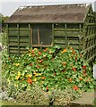
Southby's Allotments garden shed
A good display of Tropaeolum majus (Nasturtium to you and me) clothes this essential part of allotment kit.
Image: © Stuart Logan
Taken: 13 Jul 2005
0.16 miles
4
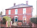
Flowering Cherry
Flowering Cherry is situated in The Folly by Stroud Green in Newbury.
It was originally built as a farmers house around 1880 (much of Stroud Green was farm land at that time)
Image: © Trevor Hickman
Taken: 31 Jan 2007
0.23 miles