IMAGES TAKEN NEAR TO
Steel Close, NEWBURY, RG14 7DT
Introduction
This page details the photographs taken nearby to Steel Close, RG14 7DT by members of the Geograph project.
The Geograph project started in 2005 with the aim of publishing, organising and preserving representative images for every square kilometre of Great Britain, Ireland and the Isle of Man.

There are currently over 7.5m images from over14,400 individuals and you can help contribute to the project by visiting https://www.geograph.org.uk
Image Map
Images are licensed for reuse under creativecommons.org/licenses/by-sa/2.0
Notes
- Clicking on the map will re-center to the selected point.
- The higher the marker number, the further away the image location is from the centre of the postcode.
Image Listing (30 Images Found)
Images are licensed for reuse under creativecommons.org/licenses/by-sa/2.0
Image
Details
Distance
1
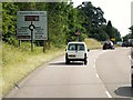
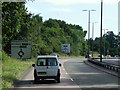
Southbound A339 near Newbury Retail Park
Image: © David Dixon
Taken: 17 Jul 2014
0.03 miles
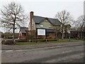
2
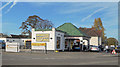
Monks Lane Valet Centre
Formerly Monks Lane Filling Station. A rare survivor of the first purpose built petrol stations which appeared in the 1930s following legislation to regulate roadside fuel sales.
It is Grade 2 listed https://historicengland.org.uk/listing/the-list/list-entry/1350330 and the entry, as well as describing the structure, contains background information about the origin of early garages as a building type.
Quote "A 1934 electric petrol filling station with known designer and patron, that is mostly intact in a distinctive style. It is a relatively uncommon survival that contributes to our understanding of this type of building that played an important role in the early-C20 landscape."
Image: © Des Blenkinsopp
Taken: 24 Oct 2018
0.04 miles
3
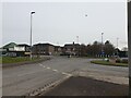
Roundabout on Newtown Road
Looking from a triangle of pavement on Monks Lane at the roundabout on Newtown Road.
Image: © Oscar Taylor
Taken: 15 Mar 2023
0.05 miles
4
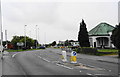
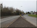
The south end of Newtown Road
This used to be the route of the A34 into Newbury. You can see the vestigial evidence that it used to run straight on here. Apart from the dual carriageway to the east, the remaining traffic has now been diverted along Monks Lane to the right.
The building on the right was once Monks Lane Garage. I remember using a carol singing sheet sponsored by this garage 40+ years ago.
Image: © Bill Boaden
Taken: 25 Aug 2010
0.05 miles
5
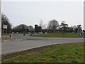
Roundabout on the A339
A roundabout on the A339, serving Monks Lane and Pinchington Lane. Behind is a Jehovah's Witnesses Kingdom Hall and Newbury Retail Park.
Image: © Oscar Taylor
Taken: 15 Mar 2023
0.06 miles
6
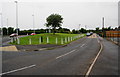
The old and new routes of Monks Lane
The newer route is over to the left. The whole road has been widened to accommodate more traffic, whereas it used to be only a small lane marking the edge of town.
Image: © Bill Boaden
Taken: 25 Aug 2010
0.07 miles
7
Monks Lane
Looking from a triangle of pavement down Monks Lane, away from the roundabout on Newtown Road.
Image: © Oscar Taylor
Taken: 15 Mar 2023
0.09 miles
9
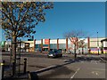
Newbury Retail Park
The retail park on the outskirts of Newbury. The shops currently trading at the site are McDonalds, Deichmann, Sports Direct, Home Bargains, Matalan, Hobbycraft, Costa Coffee, Pets at Home, Lidl, Currys, M&S Simply Food, Boots, Starbucks, Mountain Warehouse and TK Maxx.
Image: © Oscar Taylor
Taken: 7 Apr 2023
0.10 miles
10
The Two Watermills
A pub and restaurant off Monks Lane.
Image: © Oscar Taylor
Taken: 15 Mar 2023
0.10 miles