IMAGES TAKEN NEAR TO
The Marlowes, NEWBURY, RG14 7AY
Introduction
This page details the photographs taken nearby to The Marlowes, RG14 7AY by members of the Geograph project.
The Geograph project started in 2005 with the aim of publishing, organising and preserving representative images for every square kilometre of Great Britain, Ireland and the Isle of Man.

There are currently over 7.5m images from over14,400 individuals and you can help contribute to the project by visiting https://www.geograph.org.uk
Image Map
Images are licensed for reuse under creativecommons.org/licenses/by-sa/2.0
Notes
- Clicking on the map will re-center to the selected point.
- The higher the marker number, the further away the image location is from the centre of the postcode.
Image Listing (14 Images Found)
Images are licensed for reuse under creativecommons.org/licenses/by-sa/2.0
Image
Details
Distance
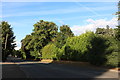
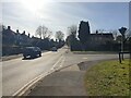
1
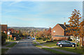
The Kennet Valley from Wendan Road
At street level houses usually block out much sense of scenery, but Wendan Road is in the right alignment to show the spread of Newbury's suburbs up the side of the Kennet valley from the town centre down by the river.
Image: © Des Blenkinsopp
Taken: 24 Oct 2018
0.09 miles
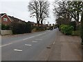
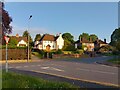
2
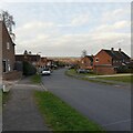
View down Wendan Road
A view north down Wendan Road, towards Newbury town centre.
Image: © Oscar Taylor
Taken: 30 Jan 2022
0.14 miles
3
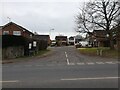
Gwyn Close
Looking from the pavement on Andover Road at Gwyn Close, a cul-de-sac off the road.
Image: © Oscar Taylor
Taken: 4 Mar 2023
0.18 miles
4
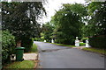
Tydehams, Newbury
A longstanding street of very desirable houses. None of the houses uses house numbers.
Image: © Bill Boaden
Taken: 25 Aug 2010
0.20 miles
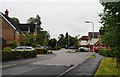
6
Andover Road
Looking south, up the hill of Andover Road (the A343). There are two speed cameras on the road. It is very busy at school times. The pavement is wide at the town centre end and is very narrow nearer to Wash Common.
Image: © Oscar Taylor
Taken: 4 Mar 2023
0.21 miles
7
Heather Gardens, Newbury
This is built on former gardens of houses on Tydehams, which used to back onto Monks Lane. For many years the residents of Tydehams resisted such a development, but it was inevitable that they would eventually succumb. I wonder whether the name is taken from one of the former owners of the gardens.
Image: © Bill Boaden
Taken: 25 Aug 2010
0.21 miles
8
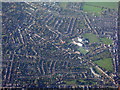
Newbury from the air
A view from the east. St Bartholomew's School is the obvious feature in the centre http://www.stbarts.co.uk/.
Image: © M J Richardson
Taken: 23 Nov 2017
0.22 miles
9
Junction of Bartlemy Road and Andover Road
Looking up Andover Road, over the junction of Andover Road. There is a side entrance to St Barts' school on Bartlemy Road, which has a sharp chicane corner. Up Andover Road are two speed cameras.
Image: © Oscar Taylor
Taken: 19 Feb 2023
0.22 miles
10
Houses on Andover Road (A343)
Detached houses on Andover Road (the A343) in Newbury, numbers 109, 111, 113 and 115 from left to right, viewed from Bartlemy Road.
Image: © Oscar Taylor
Taken: 19 May 2023
0.22 miles