IMAGES TAKEN NEAR TO
Ralphs Ride, BRACKNELL, RG12 9LE
Introduction
This page details the photographs taken nearby to Ralphs Ride, RG12 9LE by members of the Geograph project.
The Geograph project started in 2005 with the aim of publishing, organising and preserving representative images for every square kilometre of Great Britain, Ireland and the Isle of Man.

There are currently over 7.5m images from over14,400 individuals and you can help contribute to the project by visiting https://www.geograph.org.uk
Image Map
Images are licensed for reuse under creativecommons.org/licenses/by-sa/2.0
Notes
- Clicking on the map will re-center to the selected point.
- The higher the marker number, the further away the image location is from the centre of the postcode.
Image Listing (17 Images Found)
Images are licensed for reuse under creativecommons.org/licenses/by-sa/2.0
Image
Details
Distance
1
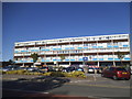
Shopping block on Ralphs Ride, Martin's Heron
Image: © David Howard
Taken: 19 Jul 2015
0.05 miles
2
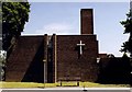
St Paul, Harmanswater
Built in 1969. This is a shared church.
Image: © Michael FORD
Taken: Unknown
0.08 miles
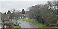
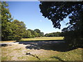
7
Playing field near Bullbrook
Pictured during a calm moment in autumn with the sun shining through rain clouds.
Image: © don cload
Taken: 20 Nov 2009
0.21 miles
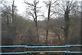
8

Water pump on Calfridus Way, Martin's Heron
Image: © David Howard
Taken: 19 Jul 2015
0.21 miles
9
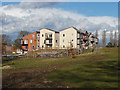
New housing, The Park Estate
These houses on Gibson Drive in the harmans Water area of Bracknell are to new to appear on any map.
Image: © Alan Hunt
Taken: 3 Mar 2015
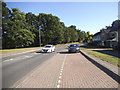
0.22 miles
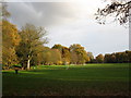
10
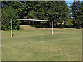
Goalposts, Allsmoor playing fields
A set of goalposts on the playing fields off Calfridus Way.
Image: © Alan Hunt
Taken: 4 Sep 2013
0.23 miles