IMAGES TAKEN NEAR TO
RG12 3EY
Introduction
This page details the photographs taken nearby to RG12 3EY by members of the Geograph project.
The Geograph project started in 2005 with the aim of publishing, organising and preserving representative images for every square kilometre of Great Britain, Ireland and the Isle of Man.

There are currently over 7.5m images from over14,400 individuals and you can help contribute to the project by visiting https://www.geograph.org.uk
Image Map
Images are licensed for reuse under creativecommons.org/licenses/by-sa/2.0
Notes
- Clicking on the map will re-center to the selected point.
- The higher the marker number, the further away the image location is from the centre of the postcode.
Image Listing (24 Images Found)
Images are licensed for reuse under creativecommons.org/licenses/by-sa/2.0
Image
Details
Distance
1
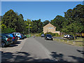
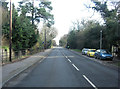
Drovers Way, Bracknell
A cul-de-sac in the housing estates of the Martin's Heron area of Bracknell. The A4, London Road is just beyond the trees behind the houses.
Image: © Alan Hunt
Taken: 4 Sep 2013
0.04 miles
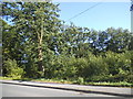
2
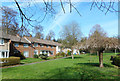
Drovers Way, Bracknell
A small green at the end of a suburban street.
Image: © Des Blenkinsopp
Taken: 13 Mar 2017
0.04 miles
3
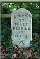
Old Milestone by the A329, London Road
Beside entrance to Scott's Hill. Opposite Lily Hill Park
Image: © Andrew Radgick
Taken: 13 May 2016
0.06 miles
4
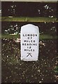
Old Milestone by the A329 in Bullbrook
Carved stone post by the A329, in parish of Bracknell (Bracknell Forest District), London Road; opposite Lily Hill Park, East of Running Horse Roundabout, on wide well kept verge between road and path in front of woodland rail fence, on South side of road. Wokingham square, erected by the Windsor Forest turnpike trust in the 19th century. Originally in front of 'Langdale', nearer to roundabout, but moved 200m East to opposite Lily Hill Park before 2011, presumably during building development work at Langdale site..
Inscription reads:-
LONDON
27
MILES
READING
12
MILES
Carved benchmark lower front face. (genuine mark, but only two legs painted)
Grade II listed.
List Entry Number: 1390343 https://historicengland.org.uk/listing/the-list/list-entry/1390343
Milestone Society National ID: BE_LRV27
Image: © A Rosevear
Taken: 28 Aug 2002
0.06 miles
6
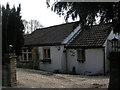
Tollhouse by London Road, Bracknell
Tollhouse in the parish of Bracknell (Bracknell Forest District), Old Tollgate Cottage, London Road, RG12 9FN.
The Tollhouse may have been demolished to provide access for 'Old Toll Gate Close'.
Surveyed
Milestone Society National ID: BE.BRA
Image: © Alan Rosevear
Taken: Unknown
0.09 miles
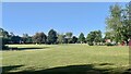
8
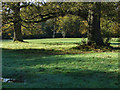
Lily Hill Park, sports ground
A rugby pitch occupies the part of Lily Hill Park alongside the A329, London Road.
Image: © Alan Hunt
Taken: 4 Nov 2014
0.13 miles
9
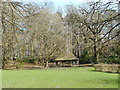
Shelter in Lily Hill Park
The grounds of a former country house built around 1815, now a park.
Image: © Des Blenkinsopp
Taken: 13 Mar 2017
0.13 miles
10
Allsmoor Field
Open grassland with playground area.
Image: © James Emmans
Taken: 16 Jun 2021
0.13 miles