1
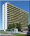
Nibbling away the 3M building
After many years of dereliction ( see earlier photo http://www.geograph.org.uk/photo/1238347) the building is finally being demolished.
Image: © don cload
Taken: 9 Jan 2015
0.01 miles
2
Demolition of the 3M Building continues
Image: © Roger Templeman
Taken: 11 Mar 2015
0.02 miles
3
Derelict Office Block, Bracknell
Once the offices for the 3M company, now empty and vandalised.
Image: © don cload
Taken: 4 Apr 2009
0.02 miles
4
Winchester House, Bracknell
Quite a landmark in the town by virtue of its size and bright yellow spandrels. It was built in 1971. Since its previous occupants, 3M, left in 2003 it has lain empty, slowly rotting while conversion schemes have come and gone. Nothing definite is on the horizon at the time of writing.
Image: © Stephen Richards
Taken: 26 Jun 2011
0.04 miles
5
Bracknell Regeneration - Early stage
New town centre at early construction stage. 3M Building has been demolished
Image: © Rob Motha
Taken: 16 Aug 2015
0.04 miles
6
Old Milestone by the former A329
Outside Blue's Smokehouse
Image: © Andrew Radgick
Taken: 7 Jun 2016
0.04 miles
7
Old Milestone by the former A329 in Bracknell
Carved stone post by the former A329, in parish of Bracknell (Bracknell Forest District), High Street; by the "Blues Smokehouse Restaurant" (was Red Lion PH), near Market Place, by wall of the pub in the pedestrian area paving, on North side of road. Wokingham square, erected by the Windsor Forest turnpike trust in the 19th century.
Inscription reads:-
: TO / LONDON / 28 : : TO / READING / 11 :
Grade II listed.
List Entry Number: 1390341 https://historicengland.org.uk/listing/the-list/list-entry/1390341
Milestone Society National ID: BE_LRV28
Image: © A Rosevear
Taken: 28 Aug 2002
0.04 miles
8
Old Milestone by the former A329
Outside Blue's Smokehouse
Image: © Andrew Radgick
Taken: 7 Jun 2016
0.04 miles
9
The Red Lion and Eagle House, Bracknell
The Red Lion is one of the surviving buildings from a time when Bracknell was just a couple of villages and countryside. The new town was established in 1949 to provide homes and a better environment to live in for Londoners. The copper-tinted office block is on the edge of and above the town's main shopping centre. It reflects a derelict one that towers over the market place which is to the left of the pub.
Image: © Andrew Smith
Taken: 1 Jul 2008
0.04 miles
10
Eagle House, Bracknell
The reflecting sun means that the shadows on the High Street on this summer evening point west. I don't think I am being to controversial in expressing the opinion that the architecture around the town centre is unattractive. This view is a bit better than most and incorporates the Red Lion pub, one of only a couple of old buildings in the immediate vicinity..
Image: © Andrew Smith
Taken: 1 Jul 2008
0.04 miles


