IMAGES TAKEN NEAR TO
Braccan Walk, BRACKNELL, RG12 1HA
Introduction
This page details the photographs taken nearby to Braccan Walk, RG12 1HA by members of the Geograph project.
The Geograph project started in 2005 with the aim of publishing, organising and preserving representative images for every square kilometre of Great Britain, Ireland and the Isle of Man.

There are currently over 7.5m images from over14,400 individuals and you can help contribute to the project by visiting https://www.geograph.org.uk
Image Map
Images are licensed for reuse under creativecommons.org/licenses/by-sa/2.0
Notes
- Clicking on the map will re-center to the selected point.
- The higher the marker number, the further away the image location is from the centre of the postcode.
Image Listing (88 Images Found)
Images are licensed for reuse under creativecommons.org/licenses/by-sa/2.0
Image
Details
Distance
1
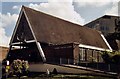
Church of St Joseph, Bracknell
Erected in 1962 for the Roman Catholics.
Image: © Michael FORD
Taken: Unknown
0.02 miles
2
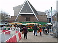
Christmas Market by St Joseph Church
The church dates from the early 1960s(?)
Image: © Sam
Taken: 17 Dec 2016
0.02 miles
3
Entrance to Atrium Court - Bracknell
A building originally occupied by the Oracle software company.
Image: © David Lally
Taken: 27 Oct 2007
0.04 miles
4
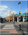
Bracknell Bus Station, view towards Princess Square
Image: © Sam
Taken: 30 Nov 2015
0.05 miles
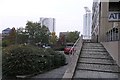
5
Towards the Town Centre
Urban scenery north of the railway.
Image: © Des Blenkinsopp
Taken: 3 Apr 2017
0.07 miles
6
A Bracknell town centre scene
Taken from outside the entrance to the hotel seen in Image
Image: © David Lally
Taken: 26 Oct 2007
0.07 miles
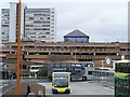
8
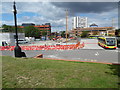
Bracknell Bus Station (2)
Situated in Station Road RG12 1HY, this bus station was being rebuilt at the time this photo was taken. A Courtney single-decker bus can be seen to the right of the photo. Behind the bus station is the Princess Square Shopping Centre and the tall Ocean House office building. To the left of the photo is the Columbia Centre office block.
Image: © David Hillas
Taken: 30 Jul 2015
0.08 miles
9
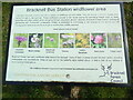
Close-up view of wildflower information board at Bracknell Bus Station
This photo shows a close up view of the wildflower information board at the east side of Bracknell Bus Station. It has the following wording:
Bracknell Bus Station wildflower area
This bank has been transformed with a mixture of wildflower turf and seeds.
This will ensure a colourful display from spring through to late summer. These
wildflowers provide a rich nectar source for pollinating insects such as bees,
butterflies and other insects which are going through population decline
nationally. Bracknell Forest Council, working in partnership with Continental
Landscapes Limited, is committed to contributing to the reversal of this
decline and will manage green spaces across the borough to improve their
wildlife potential.
Flowers present in this turf include:
images from left to right.
Common knapweed
Musk mallow
Devil's bit scabious
Yarrow
Lady's bedstraw
Red clover
Tufted vetch
Bracknell Forest has many wildflower sites around the borough, many of them in
areas around the town centre, including underpasses and roundabouts. Keep an
eye out for the butterfly signs dotted about, or take a look at our website at
www.bracknell-forest.gov.uk.
This wildflower meadow is sponsored and maintained by Continental Landscapes
Ltd.
Image: © David Hillas
Taken: 8 Apr 2022
0.08 miles
10
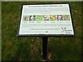
Wildflower Information Board at Bracknell Bus Station
This information board is at the east end of the Bus Station in Station Way. The wording on this board is at https://www.geograph.org.uk/photo/7147908.
Image: © David Hillas
Taken: 8 Apr 2022
0.08 miles