IMAGES TAKEN NEAR TO
RG11 9UE
Introduction
This page details the photographs taken nearby to RG11 9UE by members of the Geograph project.
The Geograph project started in 2005 with the aim of publishing, organising and preserving representative images for every square kilometre of Great Britain, Ireland and the Isle of Man.

There are currently over 7.5m images from over14,400 individuals and you can help contribute to the project by visiting https://www.geograph.org.uk
Image Map
Images are licensed for reuse under creativecommons.org/licenses/by-sa/2.0
Notes
- Clicking on the map will re-center to the selected point.
- The higher the marker number, the further away the image location is from the centre of the postcode.
Image Listing (11 Images Found)
Images are licensed for reuse under creativecommons.org/licenses/by-sa/2.0
Image
Details
Distance
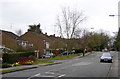
1
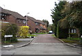
Jutland Close, Woosehill
One of the shared surface roads on this development.
Image: © john bristow
Taken: 13 Apr 2013
0.13 miles
2
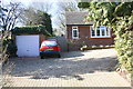
#170 Old Woosehill Lane
There is an OS benchmark Image on the right hand side of the garage, near its front corner
Image: © Roger Templeman
Taken: 27 Feb 2015
0.16 miles
3
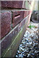
Benchmark at #170 Old Woosehill Lane
Ordnance Survey cut mark benchmark described on the Bench Mark Database at http://www.bench-marks.org.uk/bm64596
Image: © Roger Templeman
Taken: 27 Feb 2015
0.17 miles
5
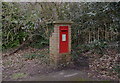
Postbox at Woosehill
This 'GR' box sits at the end of Chestnut Avenue.
Image: © john bristow
Taken: 13 Apr 2013
0.18 miles
6
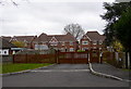
Gated development off Chestnut Avenue
The now fashionable trend in security.
Image: © john bristow
Taken: 13 Apr 2013
0.18 miles
7
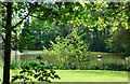
Part of Windmill Pond
A rare glimpse of this very secluded pond which is mostly hidden by trees.
Image: © Des Blenkinsopp
Taken: 15 May 2018
0.20 miles
8
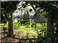
Windmill Pond from Chestnut Avenue
The pond and surrounding garden are believed to be in private ownership.
Image: © don cload
Taken: 19 Feb 2010
0.21 miles
10
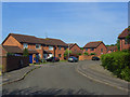
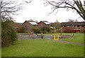
Culloden Way, Wokingham
A part of Woosehill where the roads are named after battles.
Image: © Andrew Smith
Taken: 11 May 2009
0.24 miles