IMAGES TAKEN NEAR TO
RG11 2UR
Introduction
This page details the photographs taken nearby to RG11 2UR by members of the Geograph project.
The Geograph project started in 2005 with the aim of publishing, organising and preserving representative images for every square kilometre of Great Britain, Ireland and the Isle of Man.

There are currently over 7.5m images from over14,400 individuals and you can help contribute to the project by visiting https://www.geograph.org.uk
Image Map
Images are licensed for reuse under creativecommons.org/licenses/by-sa/2.0
Notes
- Clicking on the map will re-center to the selected point.
- The higher the marker number, the further away the image location is from the centre of the postcode.
Image Listing (15 Images Found)
Images are licensed for reuse under creativecommons.org/licenses/by-sa/2.0
Image
Details
Distance
2
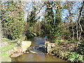
The Emm Brook
At quite a high level after the wet winter of 2014.
Image: © Bikeboy
Taken: 16 Mar 2014
0.08 miles
3
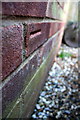
Benchmark at #170 Old Woosehill Lane
Ordnance Survey cut mark benchmark described on the Bench Mark Database at http://www.bench-marks.org.uk/bm64596
Image: © Roger Templeman
Taken: 27 Feb 2015
0.10 miles
4
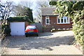
#170 Old Woosehill Lane
There is an OS benchmark Image on the right hand side of the garage, near its front corner
Image: © Roger Templeman
Taken: 27 Feb 2015
0.11 miles
6
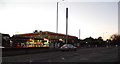
Shell petrol station on Reading Road, Emmbrook
Image: © David Howard
Taken: 8 Feb 2015
0.12 miles
7
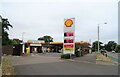
Service station on Reading Road, Wokingham
Petrol 187.9p
Diesel 197.9p.
Image: © JThomas
Taken: 26 Jul 2022
0.13 miles
9
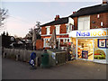
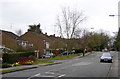
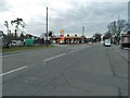
Shops on Reading Road, Emmbrook
By the Rifle Volunteer pub
Image: © David Howard
Taken: 8 Feb 2015
0.14 miles
10
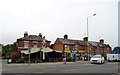
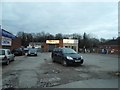
Public house and shops on Reading Road, Wokingham
Image: © JThomas
Taken: 26 Jul 2022
0.14 miles