IMAGES TAKEN NEAR TO
Bakers Lane, SOUTHPORT, PR9 9RN
Introduction
This page details the photographs taken nearby to Bakers Lane, PR9 9RN by members of the Geograph project.
The Geograph project started in 2005 with the aim of publishing, organising and preserving representative images for every square kilometre of Great Britain, Ireland and the Isle of Man.

There are currently over 7.5m images from over14,400 individuals and you can help contribute to the project by visiting https://www.geograph.org.uk
Image Map (Loading...)


Getting Data...Please wait
Leaflet Map data © OpenStreetMap
Images are licensed for reuse under creativecommons.org/licenses/by-sa/2.0
Notes
- Clicking on the map will re-center to the selected point.
- The higher the marker number, the further away the image location is from the centre of the postcode.
Image Listing (14 Images Found)
Images are licensed for reuse under creativecommons.org/licenses/by-sa/2.0
Image
Details
Distance
1
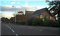
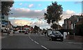
Saint Patrick's Catholic Church, Southport
At the corner of Marshside Road and Baker's Lane
Image: © David Dixon
Taken: 25 Sep 2010
0.09 miles
2
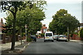
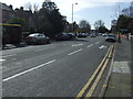
Larkfield Lane, Marshside, Southport
Image: © Mike Pennington
Taken: 8 Jul 2016
0.17 miles
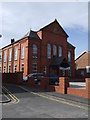
6

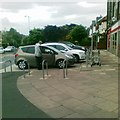
Cambridge Gardens
Retirement apartments in Churchtown.
Image: © Gerald England
Taken: 3 Mar 2014
0.22 miles
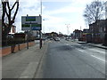
8
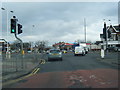
Marshside Road/Preston New Road Junction, Southport
Marshside Road, approaching its junction with Preston New Road (A565)
Image: © David Dixon
Taken: 25 Sep 2010
0.22 miles
10
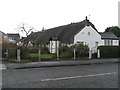
Shrimpers Cottages
Thatched cottages in Marshside
Image: © K A
Taken: 13 Dec 2009
0.24 miles