IMAGES TAKEN NEAR TO
Preesall Close, SOUTHPORT, PR9 9PJ
Introduction
This page details the photographs taken nearby to Preesall Close, PR9 9PJ by members of the Geograph project.
The Geograph project started in 2005 with the aim of publishing, organising and preserving representative images for every square kilometre of Great Britain, Ireland and the Isle of Man.

There are currently over 7.5m images from over14,400 individuals and you can help contribute to the project by visiting https://www.geograph.org.uk
Image Map (Loading...)


Getting Data...Please wait
Leaflet Map data © OpenStreetMap
Images are licensed for reuse under creativecommons.org/licenses/by-sa/2.0
Notes
- Clicking on the map will re-center to the selected point.
- The higher the marker number, the further away the image location is from the centre of the postcode.
Image Listing (12 Images Found)
Images are licensed for reuse under creativecommons.org/licenses/by-sa/2.0
Image
Details
Distance
1
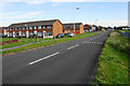
Marshside Road
Passing through outlying suburbs of Southport.
Image: © Bill Boaden
Taken: 14 Sep 2019
0.05 miles
2
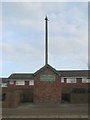
Marshside Fog Bell
The bell was erected in 1876 after the loss of seven fishermen who became lost in fog. Land reclamation has left the bell well inland now, and it is surrounded by modern housing development
Image: © K A
Taken: 13 Dec 2009
0.06 miles

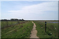
5
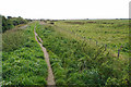
Sefton Coastal Footpath
Following a dyke on the seaward side of the housing area.
Image: © Bill Boaden
Taken: 14 Sep 2019
0.11 miles
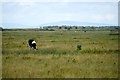
8

Cattle on Rimmer's Marsh, Marshside
Image: © Mike Pennington
Taken: 19 Oct 2015
0.17 miles
9

Sefton Coastal Path passing Rimmer's Marsh, Marshside
Image: © Mike Pennington
Taken: 19 Oct 2015
0.19 miles
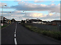
10
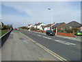
Marshside Road
Heading north towards the coast.
Image: © JThomas
Taken: 15 Mar 2014
0.20 miles