IMAGES TAKEN NEAR TO
Rawlinson Road, SOUTHPORT, PR9 9NE
Introduction
This page details the photographs taken nearby to Rawlinson Road, PR9 9NE by members of the Geograph project.
The Geograph project started in 2005 with the aim of publishing, organising and preserving representative images for every square kilometre of Great Britain, Ireland and the Isle of Man.

There are currently over 7.5m images from over14,400 individuals and you can help contribute to the project by visiting https://www.geograph.org.uk
Image Map (Loading...)


Getting Data...Please wait
Leaflet Map data © OpenStreetMap
Images are licensed for reuse under creativecommons.org/licenses/by-sa/2.0
Notes
- Clicking on the map will re-center to the selected point.
- The higher the marker number, the further away the image location is from the centre of the postcode.
Image Listing (9 Images Found)
Images are licensed for reuse under creativecommons.org/licenses/by-sa/2.0
Image
Details
Distance
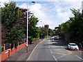
1
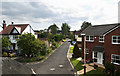
From Hesketh Drive bridge
The bridges long outlasted the Cheshire Lines railway that they spanned
Image: © Ian Greig
Taken: 5 Aug 2016
0.06 miles
2
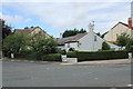
Cottages on Coudray Road
A row of fishermen's, or farm workers cottages that are typical of the Churchtown area. They have long since been surrounded by much larger and more modern housing
Image: © K A
Taken: 20 Jul 2012
0.15 miles
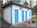
4
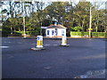
Public Toilets
Newly refurbished public toilets at Hesketh Park. Located in South East corner of this grid square facing West.
Image: © Mark Arrowsmith
Taken: 10 Dec 2005
0.17 miles
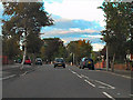
5
Cambridge Road, Churchtown
Emmanuel church seen in distance
Image: © Raymond Knapman
Taken: 8 Aug 2012
0.22 miles
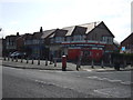
6
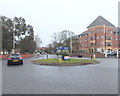
Junction of Park Crescent, Park Avenue and Cambridge Road, Southport
Image: © Gary Rogers
Taken: 24 Mar 2016
0.24 miles
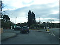
9
Public Toilets on Park Crescent, Southport
Image: © Gary Rogers
Taken: 24 Mar 2016
0.25 miles