IMAGES TAKEN NEAR TO
Park Road, SOUTHPORT, PR9 9NB
Introduction
This page details the photographs taken nearby to Park Road, PR9 9NB by members of the Geograph project.
The Geograph project started in 2005 with the aim of publishing, organising and preserving representative images for every square kilometre of Great Britain, Ireland and the Isle of Man.

There are currently over 7.5m images from over14,400 individuals and you can help contribute to the project by visiting https://www.geograph.org.uk
Image Map (Loading...)


Getting Data...Please wait
Leaflet Map data © OpenStreetMap
Images are licensed for reuse under creativecommons.org/licenses/by-sa/2.0
Notes
- Clicking on the map will re-center to the selected point.
- The higher the marker number, the further away the image location is from the centre of the postcode.
Image Listing (13 Images Found)
Images are licensed for reuse under creativecommons.org/licenses/by-sa/2.0
Image
Details
Distance
4
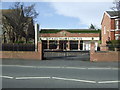
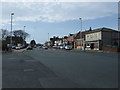
The Mount Pleasant Pub
The Mount Pleasant Pub on Manchester Road.
Image: © Sue Adair
Taken: 3 Jan 2010
0.13 miles
5
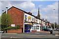
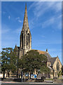
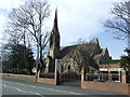
Row of shops on Manchester Road
The spire of Leyland Road Methodist Church is seen over the top of the shops
Image: © K A
Taken: 7 May 2013
0.14 miles
7
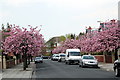
Irton Road
The cherry trees provide a dash of welcome colour in spring
Image: © K A
Taken: 7 May 2013
0.18 miles
10
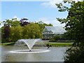
Fountain and conservatory Hesketh Park
Image: © Norman Caesar
Taken: 31 May 2015
0.24 miles