IMAGES TAKEN NEAR TO
Argyle Road, SOUTHPORT, PR9 9LD
Introduction
This page details the photographs taken nearby to Argyle Road, PR9 9LD by members of the Geograph project.
The Geograph project started in 2005 with the aim of publishing, organising and preserving representative images for every square kilometre of Great Britain, Ireland and the Isle of Man.

There are currently over 7.5m images from over14,400 individuals and you can help contribute to the project by visiting https://www.geograph.org.uk
Image Map
Images are licensed for reuse under creativecommons.org/licenses/by-sa/2.0
Notes
- Clicking on the map will re-center to the selected point.
- The higher the marker number, the further away the image location is from the centre of the postcode.
Image Listing (25 Images Found)
Images are licensed for reuse under creativecommons.org/licenses/by-sa/2.0
Image
Details
Distance
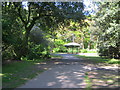
1
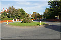
Roundabout on Hesketh Road
In the residential suburbs of Southport.
Image: © Bill Boaden
Taken: 14 Sep 2019
0.10 miles
2
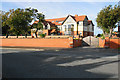
Rosefield Hall
Divided into private apartments.
Image: © Bill Boaden
Taken: 14 Sep 2019
0.12 miles
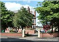
3

Roundabout at junction of Albert Road, Cliff Road and Argyle Road in Southport
Image: © Peter Robinson
Taken: 22 May 2012
0.12 miles
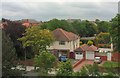
4
The Salfordian
A hotel on Park Crescent, Southport.
Image: © Gerald England
Taken: 18 May 2007
0.13 miles
5
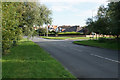
Hesketh Road
Part of the rambling residential suburbs of Southport.
Image: © Bill Boaden
Taken: 14 Sep 2019
0.13 miles
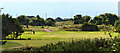
8
Houses on Brocklebank Road
Viewed from The Salfordian Image
Image: © Gerald England
Taken: 23 May 2007
0.15 miles
9
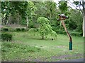
Sculpture in Hesketh Park
A sculpture among the trees in Hesketh Park, Southport.
Image: © Gerald England
Taken: 16 May 2007
0.17 miles
10

Hesketh Park
A footpath through trees at Hesketh Park.
Image: © Gerald England
Taken: 22 May 2007
0.17 miles